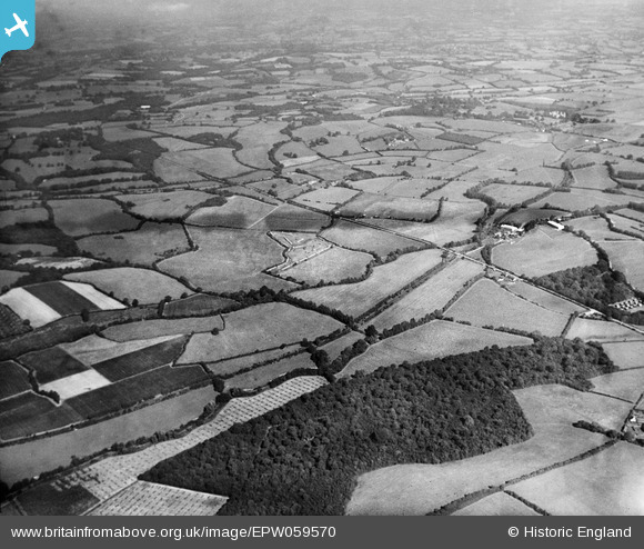
EPW059570 ENGLAND (1938). Fowlbrook Wood and Junction Road looking towards Knowl Hill, Salehurst, from the south-west, 1938
© Copyright OpenStreetMap contributors and licensed by the OpenStreetMap Foundation. 2026. Cartography is licensed as CC BY-SA.
Details
| Title | [EPW059570] Fowlbrook Wood and Junction Road looking towards Knowl Hill, Salehurst, from the south-west, 1938 |
| Reference | EPW059570 |
| Date | 23-September-1938 |
| Link | |
| Place name | SALEHURST |
| Parish | SALEHURST AND ROBERTSBRIDGE |
| District | |
| Country | ENGLAND |
| Easting / Northing | 576624, 124043 |
| Longitude / Latitude | 0.51686697802709, 50.988108899144 |
| National Grid Reference | TQ766240 |
Pins

Railway Routes |
Monday 3rd of July 2023 07:31:08 PM | |

Railway Routes |
Monday 3rd of July 2023 07:30:20 PM |


![[EPW059570] Fowlbrook Wood and Junction Road looking towards Knowl Hill, Salehurst, from the south-west, 1938](http://britainfromabove.org.uk/sites/all/libraries/aerofilms-images/public/100x100/EPW/059/EPW059570.jpg)
![[EPW059572] Fowlbrook Wood and Junction Road looking towards Round Wood and beyond, Udiam, from the south-west, 1938](http://britainfromabove.org.uk/sites/all/libraries/aerofilms-images/public/100x100/EPW/059/EPW059572.jpg)
![[EPW059257] The Rother Light Railway Line and surrounding countryside at Junction Road Halt, Udiam, 1938](http://britainfromabove.org.uk/sites/all/libraries/aerofilms-images/public/100x100/EPW/059/EPW059257.jpg)