
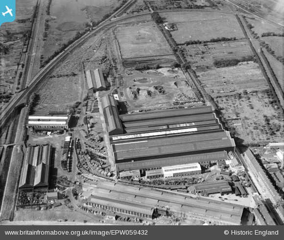
EPW059432 ENGLAND (1938). The Ruston-Bucyrus Ltd Spike Island Engineering Works, New Boultham, 1938
© Copyright OpenStreetMap contributors and licensed by the OpenStreetMap Foundation. 2026. Cartography is licensed as CC BY-SA.
Nearby Images (24)
EPW059432

EPW059425

EAW007120

EPW059427

EPW059431

EPW059426

EPW059430

EPW016180

EAW007115

EAW015717

EAW007124

EAW007116

EPW059429

EAW007122

EAW007123

EAW007121

EAW007119

EAW007126

EAW007127

EAW007125

EAW007117

EPW016181

EAW007114

EAW007118

Details
| Title | [EPW059432] The Ruston-Bucyrus Ltd Spike Island Engineering Works, New Boultham, 1938 |
| Reference | EPW059432 |
| Date | 15-September-1938 |
| Link | |
| Place name | NEW BOULTHAM |
| Parish | |
| District | |
| Country | ENGLAND |
| Easting / Northing | 496400, 370866 |
| Longitude / Latitude | -0.55583338097425, 53.225797896776 |
| National Grid Reference | SK964709 |
Pins

Popa |
Wednesday 3rd of September 2025 09:06:35 PM | |
|
Doug |
Thursday 29th of September 2022 05:45:34 PM | |
|
Ian |
Monday 12th of May 2014 04:24:09 PM | |
|
Ian |
Monday 12th of May 2014 04:18:36 PM | |
|
Ian |
Monday 12th of May 2014 04:11:32 PM | |
|
Ian |
Monday 12th of May 2014 04:03:11 PM | |
|
Ian |
Monday 12th of May 2014 04:01:38 PM | |
|
Ian |
Monday 12th of May 2014 03:56:25 PM | |
|
Ian |
Monday 12th of May 2014 03:53:28 PM | |
|
Ian |
Monday 12th of May 2014 03:51:23 PM | |
|
Ian |
Monday 12th of May 2014 03:42:23 PM | |
|
Ian |
Monday 12th of May 2014 03:41:11 PM | |
|
totoro |
Tuesday 25th of June 2013 10:34:19 PM | |
|
totoro |
Tuesday 25th of June 2013 10:33:25 PM | |
|
totoro |
Tuesday 25th of June 2013 10:32:46 PM | |
|
totoro |
Tuesday 25th of June 2013 10:32:28 PM | |
|
totoro |
Tuesday 25th of June 2013 10:30:00 PM | |
|
totoro |
Tuesday 25th of June 2013 10:29:19 PM | |
|
totoro |
Tuesday 25th of June 2013 10:28:33 PM | |
|
totoro |
Tuesday 25th of June 2013 10:27:55 PM | |
|
totoro |
Tuesday 25th of June 2013 10:25:15 PM | |
|
totoro |
Tuesday 25th of June 2013 10:24:21 PM |