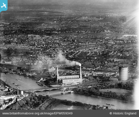
EPW059349 ENGLAND (1938). Chelsea Bridge, Battersea Power Station (Battersea A Power Station) and beyond, Battersea, from the north-west, 1938
© Copyright OpenStreetMap contributors and licensed by the OpenStreetMap Foundation. 2026. Cartography is licensed as CC BY-SA.
Details
| Title | [EPW059349] Chelsea Bridge, Battersea Power Station (Battersea A Power Station) and beyond, Battersea, from the north-west, 1938 |
| Reference | EPW059349 |
| Date | 13-September-1938 |
| Link | |
| Place name | BATTERSEA |
| Parish | |
| District | |
| Country | ENGLAND |
| Easting / Northing | 529419, 177221 |
| Longitude / Latitude | -0.13613403179585, 51.478636431168 |
| National Grid Reference | TQ294772 |
Pins

Robin |
Thursday 6th of June 2024 09:23:27 PM | |

Robin |
Thursday 6th of June 2024 09:23:04 PM | |

Class31 |
Wednesday 1st of October 2014 04:26:14 PM | |

Alan McFaden |
Sunday 4th of May 2014 07:20:08 PM | |

Alan McFaden |
Friday 18th of April 2014 09:26:35 AM | |

Alan McFaden |
Friday 18th of April 2014 09:26:03 AM | |

Alan McFaden |
Friday 18th of April 2014 09:25:27 AM | |
At the time of this picture it was the Victoria Bridge but now 'Grosvenor'. |

brianbeckett |
Monday 22nd of September 2014 02:31:27 PM |
The Battersea (Cremorne) bridge is about a mile upstream. This bridge is today known as the Grosvenor Bridge and an alternative name according to Wikipedia is the Victoria Railway Bridge. |

Class31 |
Wednesday 1st of October 2014 04:31:46 PM |
Battersea (Cremorne) Railway Bridge Is the West London Line bridge. Not this one from Victoria station. |

Leslie B |
Monday 10th of October 2022 01:03:13 PM |

Alan McFaden |
Tuesday 9th of July 2013 11:34:34 AM | |

Alan McFaden |
Tuesday 9th of July 2013 11:33:47 AM |


![[EPW059349] Chelsea Bridge, Battersea Power Station (Battersea A Power Station) and beyond, Battersea, from the north-west, 1938](http://britainfromabove.org.uk/sites/all/libraries/aerofilms-images/public/100x100/EPW/059/EPW059349.jpg)
![[EPW057039] The River Thames at Nine Elms, Pimlico and Westminster, Nine Elms, from the south-west, 1938](http://britainfromabove.org.uk/sites/all/libraries/aerofilms-images/public/100x100/EPW/057/EPW057039.jpg)
![[EAW000663] Nine Elms, Battersea, 1946](http://britainfromabove.org.uk/sites/all/libraries/aerofilms-images/public/100x100/EAW/000/EAW000663.jpg)
![[EAW029839] Battersea Power Station, cleared area around Patmore Street and the Pimlico area, Nine Elms, from the south, 1950](http://britainfromabove.org.uk/sites/all/libraries/aerofilms-images/public/100x100/EAW/029/EAW029839.jpg)


