
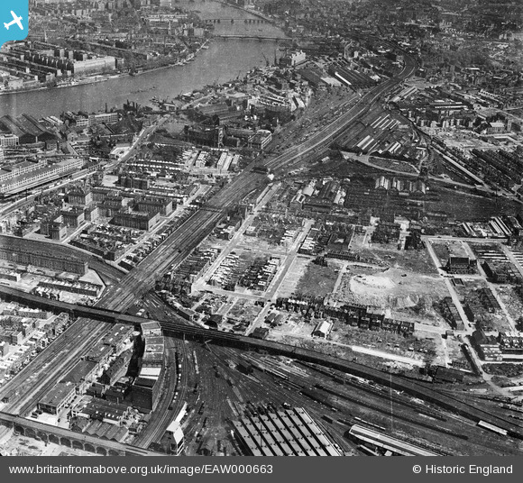
EAW000663 ENGLAND (1946). Nine Elms, Battersea, 1946
© Copyright OpenStreetMap contributors and licensed by the OpenStreetMap Foundation. 2026. Cartography is licensed as CC BY-SA.
Nearby Images (3)
EAW000663

EPW059349
 and beyond, Battersea, from the north-west, 1938")
EAW030140

Details
| Title | [EAW000663] Nine Elms, Battersea, 1946 |
| Reference | EAW000663 |
| Date | 10-May-1946 |
| Link | |
| Place name | BATTERSEA |
| Parish | |
| District | |
| Country | ENGLAND |
| Easting / Northing | 529300, 176995 |
| Longitude / Latitude | -0.13792961156984, 51.476632409419 |
| National Grid Reference | TQ293770 |
Pins

Chris Long |
Friday 19th of December 2025 02:47:16 PM | |
|
Robin |
Thursday 22nd of July 2021 09:05:50 PM | |
|
Robin |
Thursday 22nd of July 2021 09:02:02 PM | |
|
Robin |
Thursday 22nd of July 2021 08:28:56 PM | |
|
Robin |
Thursday 22nd of July 2021 08:24:26 PM | |
|
Robin |
Tuesday 5th of January 2021 01:51:33 PM | |

Maurice |
Wednesday 5th of August 2015 12:21:57 PM | |
|
Maurice |
Wednesday 5th of August 2015 12:17:33 PM | |
|
Maurice |
Wednesday 5th of August 2015 12:17:07 PM | |
|
Maurice |
Wednesday 5th of August 2015 12:16:41 PM | |
|
Deskpro |
Tuesday 5th of May 2015 02:45:58 PM | |
|
Deskpro |
Tuesday 5th of May 2015 02:44:53 PM | |

Class31 |
Saturday 28th of March 2015 07:03:10 PM | |
|
wessexpig |
Friday 6th of March 2015 06:56:42 PM |
