
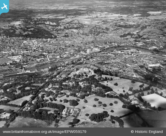
EPW059179 ENGLAND (1938). The town and environs, Ipswich, from the south-west, 1938. This image has been produced from a copy-negative.
© Copyright OpenStreetMap contributors and licensed by the OpenStreetMap Foundation. 2026. Cartography is licensed as CC BY-SA.
Nearby Images (3)
EPW059179

EAW033333

EPW032833

Details
| Title | [EPW059179] The town and environs, Ipswich, from the south-west, 1938. This image has been produced from a copy-negative. |
| Reference | EPW059179 |
| Date | 8-September-1938 |
| Link | |
| Place name | IPSWICH |
| Parish | |
| District | |
| Country | ENGLAND |
| Easting / Northing | 616139, 243683 |
| Longitude / Latitude | 1.152519578191, 52.048900504446 |
| National Grid Reference | TM161437 |
Pins

Muddy1 |
Friday 29th of November 2024 09:26:06 PM | |
|
Muddy1 |
Friday 29th of November 2024 09:20:32 PM | |
|
Muddy1 |
Friday 29th of November 2024 09:11:42 PM | |
|
Charles |
Tuesday 18th of November 2014 01:16:34 PM | |
|
Charles |
Tuesday 18th of November 2014 01:15:12 PM | |
|
Charles |
Tuesday 18th of November 2014 01:14:05 PM | |
|
Charles |
Tuesday 18th of November 2014 01:12:51 PM | |
|
Charles |
Tuesday 18th of November 2014 01:11:33 PM | |
Really? I'd like to see the evidence for this. It's apartments now. |
Where's Canning Town? |
Tuesday 25th of November 2014 10:41:04 PM |
|
Where's Canning Town? |
Tuesday 28th of October 2014 10:49:25 PM |
