
EAW033333 ENGLAND (1950). Stoke and the town, Ipswich, 1950

© Copyright OpenStreetMap contributors and licensed by the OpenStreetMap Foundation. 2026. Cartography is licensed as CC BY-SA.
Nearby Images (3)
EAW033333

EPW059179

EAW053511

Details
| Title | [EAW033333] Stoke and the town, Ipswich, 1950 |
| Reference | EAW033333 |
| Date | 5-October-1950 |
| Link | |
| Place name | IPSWICH |
| Parish | |
| District | |
| Country | ENGLAND |
| Easting / Northing | 616224, 243614 |
| Longitude / Latitude | 1.1537136705413, 52.048247870104 |
| National Grid Reference | TM162436 |
Pins

Where's Canning Town? |
Sunday 6th of November 2016 11:48:34 PM | |
|
Where's Canning Town? |
Thursday 5th of June 2014 12:45:27 PM |

User Comment Contributions

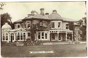
Broadwater Military Hospital on the Belstead Road, run by the Red Cross in World War One. The forty-three bedded auxiliary hospital came under the control of Colchester military hospital |
Where's Canning Town? |
Wednesday 4th of June 2014 10:52:54 PM |
Postcard showing soldiers recuperating. |
Where's Canning Town? |
Wednesday 4th of June 2014 10:50:52 PM |