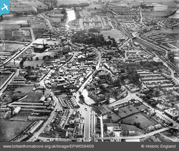
EPW058409 ENGLAND (1938). The town, Clitheroe, from the north-east, 1938
© Copyright OpenStreetMap contributors and licensed by the OpenStreetMap Foundation. 2026. Cartography is licensed as CC BY-SA.
Nearby Images (8)
Details
| Title | [EPW058409] The town, Clitheroe, from the north-east, 1938 |
| Reference | EPW058409 |
| Date | 28-July-1938 |
| Link | |
| Place name | CLITHEROE |
| Parish | CLITHEROE |
| District | |
| Country | ENGLAND |
| Easting / Northing | 374596, 442131 |
| Longitude / Latitude | -2.3864315895224, 53.874553184939 |
| National Grid Reference | SD746421 |
Pins

MB |
Wednesday 29th of January 2014 10:07:25 AM |


![[EPW058409] The town, Clitheroe, from the north-east, 1938](http://britainfromabove.org.uk/sites/all/libraries/aerofilms-images/public/100x100/EPW/058/EPW058409.jpg)
![[EPW013099] The town centre, Clitheroe, 1925. This image has been produced from a copy-negative.](http://britainfromabove.org.uk/sites/all/libraries/aerofilms-images/public/100x100/EPW/013/EPW013099.jpg)
![[EPW038844] The Market Place and environs, Clitheroe, 1932. This image has been produced from a copy-negative.](http://britainfromabove.org.uk/sites/all/libraries/aerofilms-images/public/100x100/EPW/038/EPW038844.jpg)
![[EAW020415] John Southworth and Sons Ltd Jubilee Cotton Mill, Clitheroe, from the west, 1948. This image was marked by Aerofilms Ltd for photo editing.](http://britainfromabove.org.uk/sites/all/libraries/aerofilms-images/public/100x100/EAW/020/EAW020415.jpg)
![[EAW020416] John Southworth and Sons Ltd Jubilee Cotton Mill, Clitheroe, from the north-west, 1948. This image was marked by Aerofilms Ltd for photo editing.](http://britainfromabove.org.uk/sites/all/libraries/aerofilms-images/public/100x100/EAW/020/EAW020416.jpg)
![[EPW058408] The Market Place and environs, Clitheroe, 1938](http://britainfromabove.org.uk/sites/all/libraries/aerofilms-images/public/100x100/EPW/058/EPW058408.jpg)
![[EPW038842] Cricket ground on Chatburn Road and environs, Clitheroe, 1932](http://britainfromabove.org.uk/sites/all/libraries/aerofilms-images/public/100x100/EPW/038/EPW038842.jpg)
![[EAW020411] John Southworth and Sons Ltd Jubilee Cotton Mill, Clitheroe, from the west, 1948. This image was marked by Aerofilms Ltd for photo editing.](http://britainfromabove.org.uk/sites/all/libraries/aerofilms-images/public/100x100/EAW/020/EAW020411.jpg)