
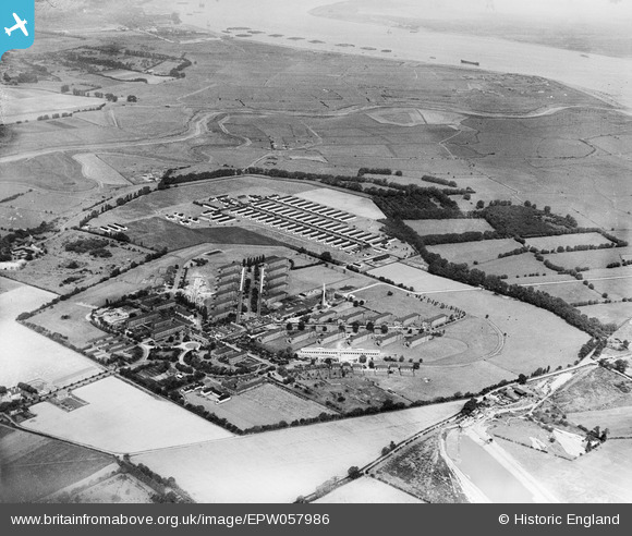
EPW057986 ENGLAND (1938). Orchard and Joyce Green Infectious Diseases Hospitals, Dartford Marshes, 1938
© Copyright OpenStreetMap contributors and licensed by the OpenStreetMap Foundation. 2026. Cartography is licensed as CC BY-SA.
Details
| Title | [EPW057986] Orchard and Joyce Green Infectious Diseases Hospitals, Dartford Marshes, 1938 |
| Reference | EPW057986 |
| Date | 17-July-1938 |
| Link | |
| Place name | DARTFORD MARSHES |
| Parish | |
| District | |
| Country | ENGLAND |
| Easting / Northing | 554552, 176310 |
| Longitude / Latitude | 0.22515810987434, 51.464141659622 |
| National Grid Reference | TQ546763 |
Pins

Ferrers |
Wednesday 3rd of March 2021 08:20:40 PM | |

Kentishman |
Monday 25th of January 2016 09:53:28 PM | |
See also EPW001410 for a 1920 image of the airfield buildings and the Long Reach Tavern. |
Kentishman |
Sunday 4th of September 2016 10:55:53 AM |
|
Kentishman |
Friday 22nd of January 2016 10:47:23 AM | |
|
Kentishman |
Friday 22nd of January 2016 10:42:30 AM | |
|
Kentishman |
Friday 22nd of January 2016 09:35:19 AM | |
|
Kentishman |
Friday 22nd of January 2016 09:33:31 AM | |
|
Kentishman |
Thursday 21st of January 2016 08:42:38 PM | |
|
Kentishwolf |
Tuesday 7th of July 2015 07:42:53 PM | |
The main buildings were clustered around the Long Reach Tavern which was off this image, over to the right. See image EPW001410 for these as at 1920. |
Kentishman |
Monday 5th of September 2016 08:32:54 AM |
|
dadave |
Monday 26th of August 2013 12:49:03 AM |
User Comment Contributions

The site of RFC/RAF Joyce Green. WW1 airfield. |
Kentishwolf |
Tuesday 7th of July 2015 07:41:29 PM |