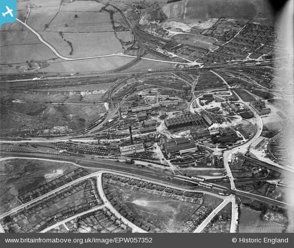
EPW057352 ENGLAND (1938). The Staveley Coal and Iron Company Ltd Works, Staveley, 1938
© Copyright OpenStreetMap contributors and licensed by the OpenStreetMap Foundation. 2026. Cartography is licensed as CC BY-SA.
Nearby Images (16)
Details
| Title | [EPW057352] The Staveley Coal and Iron Company Ltd Works, Staveley, 1938 |
| Reference | EPW057352 |
| Date | 3-June-1938 |
| Link | |
| Place name | STAVELEY |
| Parish | STAVELEY |
| District | |
| Country | ENGLAND |
| Easting / Northing | 441329, 374910 |
| Longitude / Latitude | -1.3802379610851, 53.269291464307 |
| National Grid Reference | SK413749 |
Pins
Be the first to add a comment to this image!


![[EPW057352] The Staveley Coal and Iron Company Ltd Works, Staveley, 1938](http://britainfromabove.org.uk/sites/all/libraries/aerofilms-images/public/100x100/EPW/057/EPW057352.jpg)
![[EPW041671] The Staveley Iron Works and environs, Staveley, 1933](http://britainfromabove.org.uk/sites/all/libraries/aerofilms-images/public/100x100/EPW/041/EPW041671.jpg)
![[EAW044348] The Staveley Coal and Iron Company Ltd Works, Staveley, 1952](http://britainfromabove.org.uk/sites/all/libraries/aerofilms-images/public/100x100/EAW/044/EAW044348.jpg)
![[EPW041666] The Staveley Iron Works, Staveley, 1933](http://britainfromabove.org.uk/sites/all/libraries/aerofilms-images/public/100x100/EPW/041/EPW041666.jpg)
![[EAW003057] The Staveley Iron Works, Staveley Works Station and environs, Staveley, 1946](http://britainfromabove.org.uk/sites/all/libraries/aerofilms-images/public/100x100/EAW/003/EAW003057.jpg)
![[EAW003072] The Staveley Iron Works, Staveley, 1946](http://britainfromabove.org.uk/sites/all/libraries/aerofilms-images/public/100x100/EAW/003/EAW003072.jpg)
![[EPW041669] The Staveley Iron Works, Staveley, 1933](http://britainfromabove.org.uk/sites/all/libraries/aerofilms-images/public/100x100/EPW/041/EPW041669.jpg)
![[EPW041665] The Staveley Iron Works, Staveley, 1933](http://britainfromabove.org.uk/sites/all/libraries/aerofilms-images/public/100x100/EPW/041/EPW041665.jpg)
![[EPW041668] The Staveley Iron Works and environs, Staveley, 1933](http://britainfromabove.org.uk/sites/all/libraries/aerofilms-images/public/100x100/EPW/041/EPW041668.jpg)
![[EPW041667] The Staveley Iron Works, Staveley, 1933](http://britainfromabove.org.uk/sites/all/libraries/aerofilms-images/public/100x100/EPW/041/EPW041667.jpg)
![[EPW057341] The Staveley Coal and Iron Company Ltd Works, Staveley, 1938](http://britainfromabove.org.uk/sites/all/libraries/aerofilms-images/public/100x100/EPW/057/EPW057341.jpg)
![[EPW041672] The Staveley Iron Works, Staveley, 1933. This image has been affected by flare.](http://britainfromabove.org.uk/sites/all/libraries/aerofilms-images/public/100x100/EPW/041/EPW041672.jpg)
![[EPW057342] The Staveley Coal and Iron Company Ltd Works, Staveley, 1938](http://britainfromabove.org.uk/sites/all/libraries/aerofilms-images/public/100x100/EPW/057/EPW057342.jpg)
![[EPW041670] The Staveley Iron Works and environs, Staveley, 1933](http://britainfromabove.org.uk/sites/all/libraries/aerofilms-images/public/100x100/EPW/041/EPW041670.jpg)
![[EPW057335] The Staveley Coal and Iron Company Ltd Works, Staveley, 1938. This image has been affected by flare.](http://britainfromabove.org.uk/sites/all/libraries/aerofilms-images/public/100x100/EPW/057/EPW057335.jpg)
![[EAW003058] The Staveley Iron Works and environs, Staveley, from the south-east, 1946](http://britainfromabove.org.uk/sites/all/libraries/aerofilms-images/public/100x100/EAW/003/EAW003058.jpg)