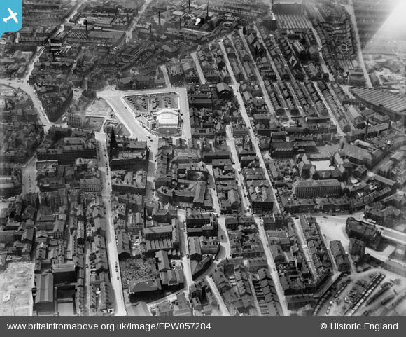
EPW057284 ENGLAND (1938). Portland Street and environs, Halifax, 1938
© Copyright OpenStreetMap contributors and licensed by the OpenStreetMap Foundation. 2026. Cartography is licensed as CC BY-SA.
Nearby Images (15)
Details
| Title | [EPW057284] Portland Street and environs, Halifax, 1938 |
| Reference | EPW057284 |
| Date | 25-May-1938 |
| Link | |
| Place name | HALIFAX |
| Parish | |
| District | |
| Country | ENGLAND |
| Easting / Northing | 409267, 425425 |
| Longitude / Latitude | -1.8595367278911, 53.724922474768 |
| National Grid Reference | SE093254 |
Pins

Tonemart |
Saturday 21st of December 2013 06:55:05 PM |
User Comment Contributions

Another one of the new (2012) Broad Street Plaza. |

Tonemart |
Saturday 21st of December 2013 06:57:08 PM |


![[EPW057284] Portland Street and environs, Halifax, 1938](http://britainfromabove.org.uk/sites/all/libraries/aerofilms-images/public/100x100/EPW/057/EPW057284.jpg)
![[EPW036891] The Town Hall and the town centre, Halifax, 1931](http://britainfromabove.org.uk/sites/all/libraries/aerofilms-images/public/100x100/EPW/036/EPW036891.jpg)
![[EPW036890] The Town Hall and the town centre, Halifax, 1931](http://britainfromabove.org.uk/sites/all/libraries/aerofilms-images/public/100x100/EPW/036/EPW036890.jpg)
![[EPW036889] Old Market and the town centre, Halifax, 1931](http://britainfromabove.org.uk/sites/all/libraries/aerofilms-images/public/100x100/EPW/036/EPW036889.jpg)
![[EPW057283] The town centre, Halifax, 1938](http://britainfromabove.org.uk/sites/all/libraries/aerofilms-images/public/100x100/EPW/057/EPW057283.jpg)
![[EAW015958] The Richard Whitaker & Sons Ltd Brewery on Corporation Street, Halifax, 1948. This image has been produced from a print.](http://britainfromabove.org.uk/sites/all/libraries/aerofilms-images/public/100x100/EAW/015/EAW015958.jpg)
![[EAW028059] Barum Top, Bull Green and environs, Halifax, 1950](http://britainfromabove.org.uk/sites/all/libraries/aerofilms-images/public/100x100/EAW/028/EAW028059.jpg)
![[EAW015954] The Richard Whitaker & Sons Ltd Brewery on Corporation Street and nearby mills and houses, Halifax, 1948. This image has been produced from a print.](http://britainfromabove.org.uk/sites/all/libraries/aerofilms-images/public/100x100/EAW/015/EAW015954.jpg)
![[EAW015959] The Richard Whitaker & Sons Ltd Brewery on Corporation Street, Halifax, 1948. This image has been produced from a print.](http://britainfromabove.org.uk/sites/all/libraries/aerofilms-images/public/100x100/EAW/015/EAW015959.jpg)
![[EAW015956] The Richard Whitaker & Sons Ltd Brewery on Corporation Street and nearby mills and houses, Halifax, 1948. This image has been produced from a print.](http://britainfromabove.org.uk/sites/all/libraries/aerofilms-images/public/100x100/EAW/015/EAW015956.jpg)
![[EAW015955] The Richard Whitaker & Sons Ltd Brewery on Corporation Street and nearby mills and houses, Halifax, 1948. This image has been produced from a print.](http://britainfromabove.org.uk/sites/all/libraries/aerofilms-images/public/100x100/EAW/015/EAW015955.jpg)
![[EPW057281] North Bridge and environs, Halifax, 1938](http://britainfromabove.org.uk/sites/all/libraries/aerofilms-images/public/100x100/EPW/057/EPW057281.jpg)
![[EAW015952] The Richard Whitaker & Sons Ltd Brewery on Corporation Street and nearby mills and houses, Halifax, 1948. This image has been produced from a print.](http://britainfromabove.org.uk/sites/all/libraries/aerofilms-images/public/100x100/EAW/015/EAW015952.jpg)
![[EAW015953] The Richard Whitaker & Sons Ltd Brewery on Corporation Street and nearby mills and houses, Halifax, 1948. This image has been produced from a print.](http://britainfromabove.org.uk/sites/all/libraries/aerofilms-images/public/100x100/EAW/015/EAW015953.jpg)
![[EPW057285] Woolshops and environs, Halifax, 1938](http://britainfromabove.org.uk/sites/all/libraries/aerofilms-images/public/100x100/EPW/057/EPW057285.jpg)
