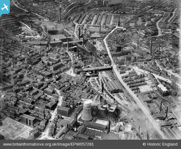
EPW057281 ENGLAND (1938). North Bridge and environs, Halifax, 1938
© Copyright OpenStreetMap contributors and licensed by the OpenStreetMap Foundation. 2026. Cartography is licensed as CC BY-SA.
Nearby Images (14)
Details
| Title | [EPW057281] North Bridge and environs, Halifax, 1938 |
| Reference | EPW057281 |
| Date | 25-May-1938 |
| Link | |
| Place name | HALIFAX |
| Parish | |
| District | |
| Country | ENGLAND |
| Easting / Northing | 409367, 425660 |
| Longitude / Latitude | -1.8580138804877, 53.727033125591 |
| National Grid Reference | SE094257 |
Pins

roobee |
Friday 28th of April 2023 08:05:52 PM | |

roobee |
Friday 28th of April 2023 08:05:31 PM | |

AC |
Sunday 21st of July 2013 08:54:11 AM |


![[EPW057281] North Bridge and environs, Halifax, 1938](http://britainfromabove.org.uk/sites/all/libraries/aerofilms-images/public/100x100/EPW/057/EPW057281.jpg)
![[EPW036893] North Bridge, North Bridge Station and environs, Halifax, 1931](http://britainfromabove.org.uk/sites/all/libraries/aerofilms-images/public/100x100/EPW/036/EPW036893.jpg)
![[EPW036894] North Bridge, North Bridge Station and environs, Halifax, 1931](http://britainfromabove.org.uk/sites/all/libraries/aerofilms-images/public/100x100/EPW/036/EPW036894.jpg)
![[EPW036892] North Bridge and environs, Halifax, 1931](http://britainfromabove.org.uk/sites/all/libraries/aerofilms-images/public/100x100/EPW/036/EPW036892.jpg)
![[EAW015954] The Richard Whitaker & Sons Ltd Brewery on Corporation Street and nearby mills and houses, Halifax, 1948. This image has been produced from a print.](http://britainfromabove.org.uk/sites/all/libraries/aerofilms-images/public/100x100/EAW/015/EAW015954.jpg)
![[EAW015958] The Richard Whitaker & Sons Ltd Brewery on Corporation Street, Halifax, 1948. This image has been produced from a print.](http://britainfromabove.org.uk/sites/all/libraries/aerofilms-images/public/100x100/EAW/015/EAW015958.jpg)
![[EAW015953] The Richard Whitaker & Sons Ltd Brewery on Corporation Street and nearby mills and houses, Halifax, 1948. This image has been produced from a print.](http://britainfromabove.org.uk/sites/all/libraries/aerofilms-images/public/100x100/EAW/015/EAW015953.jpg)
![[EAW015959] The Richard Whitaker & Sons Ltd Brewery on Corporation Street, Halifax, 1948. This image has been produced from a print.](http://britainfromabove.org.uk/sites/all/libraries/aerofilms-images/public/100x100/EAW/015/EAW015959.jpg)
![[EAW015956] The Richard Whitaker & Sons Ltd Brewery on Corporation Street and nearby mills and houses, Halifax, 1948. This image has been produced from a print.](http://britainfromabove.org.uk/sites/all/libraries/aerofilms-images/public/100x100/EAW/015/EAW015956.jpg)
![[EAW015952] The Richard Whitaker & Sons Ltd Brewery on Corporation Street and nearby mills and houses, Halifax, 1948. This image has been produced from a print.](http://britainfromabove.org.uk/sites/all/libraries/aerofilms-images/public/100x100/EAW/015/EAW015952.jpg)
![[EAW015955] The Richard Whitaker & Sons Ltd Brewery on Corporation Street and nearby mills and houses, Halifax, 1948. This image has been produced from a print.](http://britainfromabove.org.uk/sites/all/libraries/aerofilms-images/public/100x100/EAW/015/EAW015955.jpg)
![[EAW015957] The Richard Whitaker & Sons Ltd Brewery on Corporation Street and nearby mills and houses, Halifax, 1948. This image has been produced from a print.](http://britainfromabove.org.uk/sites/all/libraries/aerofilms-images/public/100x100/EAW/015/EAW015957.jpg)
![[EPW057284] Portland Street and environs, Halifax, 1938](http://britainfromabove.org.uk/sites/all/libraries/aerofilms-images/public/100x100/EPW/057/EPW057284.jpg)
![[EAW028061] Halifax Power Station and North Bridge Goods Station, Halifax, 1950](http://britainfromabove.org.uk/sites/all/libraries/aerofilms-images/public/100x100/EAW/028/EAW028061.jpg)