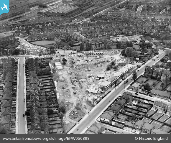
EPW056898 ENGLAND (1938). Construction of new housing by The Grange and Prout Grove, Dudden Hill, 1938
© Copyright OpenStreetMap contributors and licensed by the OpenStreetMap Foundation. 2025. Cartography is licensed as CC BY-SA.
Details
| Title | [EPW056898] Construction of new housing by The Grange and Prout Grove, Dudden Hill, 1938 |
| Reference | EPW056898 |
| Date | 26-April-1938 |
| Link | |
| Place name | DUDDEN HILL |
| Parish | |
| District | |
| Country | ENGLAND |
| Easting / Northing | 521508, 185715 |
| Longitude / Latitude | -0.24707837500374, 51.556737840619 |
| National Grid Reference | TQ215857 |
Pins

FramptonStreetBoy |
Saturday 9th of July 2022 10:06:28 PM | |

FramptonStreetBoy |
Saturday 9th of July 2022 10:04:43 PM | |

FramptonStreetBoy |
Saturday 9th of July 2022 10:04:10 PM | |

FramptonStreetBoy |
Saturday 9th of July 2022 10:03:20 PM | |

FramptonStreetBoy |
Saturday 9th of July 2022 10:01:49 PM |


![[EPW056898] Construction of new housing by The Grange and Prout Grove, Dudden Hill, 1938](http://britainfromabove.org.uk/sites/all/libraries/aerofilms-images/public/100x100/EPW/056/EPW056898.jpg)
![[EPW056897] Construction of new housing by The Grange and Prout Grove, Dudden Hill, 1938](http://britainfromabove.org.uk/sites/all/libraries/aerofilms-images/public/100x100/EPW/056/EPW056897.jpg)
![[EPW038702] The Circle and housing off the North Circular Road, Neasden, from the south, 1932. This image has been produced from a damaged negative.](http://britainfromabove.org.uk/sites/all/libraries/aerofilms-images/public/100x100/EPW/038/EPW038702.jpg)