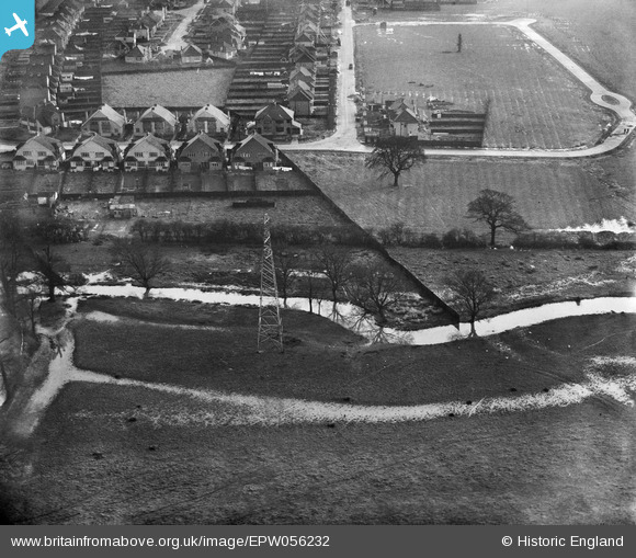
EPW056232 ENGLAND (1937). Riverview Road and Hogsmill River, Ewell, 1937
© Copyright OpenStreetMap contributors and licensed by the OpenStreetMap Foundation. 2025. Cartography is licensed as CC BY-SA.
Nearby Images (7)
Details
| Title | [EPW056232] Riverview Road and Hogsmill River, Ewell, 1937 |
| Reference | EPW056232 |
| Date | 14-December-1937 |
| Link | |
| Place name | EWELL |
| Parish | |
| District | |
| Country | ENGLAND |
| Easting / Northing | 520308, 165037 |
| Longitude / Latitude | -0.27141997840283, 51.371131943649 |
| National Grid Reference | TQ203650 |
Pins
Be the first to add a comment to this image!
User Comment Contributions
Incredible - I live at 19 Riverview Road which was built in 1935 (have land deeds) only half the street built! The un-built loop becomes Curtis Road - named after the sisters who owned the farm and sold it for building. I can fill in other detail including the Tolworth Court Farm field name in foreground on this and other related images if that would be useful. Part of this image falls in the Parish of Long Ditton (foreground) and the rest in Parsh of Ewell (St.Mary's. Ailsa) |
 Ailsa |
Wednesday 11th of September 2013 10:33:48 PM |


![[EPW056232] Riverview Road and Hogsmill River, Ewell, 1937](http://britainfromabove.org.uk/sites/all/libraries/aerofilms-images/public/100x100/EPW/056/EPW056232.jpg)
![[EPW056234] Riverview Road and Hogsmill River, Ewell, 1937](http://britainfromabove.org.uk/sites/all/libraries/aerofilms-images/public/100x100/EPW/056/EPW056234.jpg)
![[EPW056237] Tolworth Court Bridge over the Hogsmill River, Ewell, 1937](http://britainfromabove.org.uk/sites/all/libraries/aerofilms-images/public/100x100/EPW/056/EPW056237.jpg)
![[EPW056233] Kingston Road and Hogsmill River, Tolworth, 1937](http://britainfromabove.org.uk/sites/all/libraries/aerofilms-images/public/100x100/EPW/056/EPW056233.jpg)
![[EPW056238] Mortimer Crescent and Hogsmill River, Ewell, 1937](http://britainfromabove.org.uk/sites/all/libraries/aerofilms-images/public/100x100/EPW/056/EPW056238.jpg)
![[EPW052385] The River Hogsmill in flood by the Ruxley Sewage Works, Ewell, 1937. This image has been produced from a print.](http://britainfromabove.org.uk/sites/all/libraries/aerofilms-images/public/100x100/EPW/052/EPW052385.jpg)
![[EPW052354] The River Hogsmill next to Worcester Park and Mortimer Crescent, Ewell, 1937. This image has been produced from a copy-negative.](http://britainfromabove.org.uk/sites/all/libraries/aerofilms-images/public/100x100/EPW/052/EPW052354.jpg)