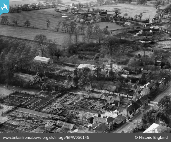
EPW056145 ENGLAND (1937). The Dairy and The Gables, Fenstanton, 1937
© Copyright OpenStreetMap contributors and licensed by the OpenStreetMap Foundation. 2025. Cartography is licensed as CC BY-SA.
Nearby Images (6)
Details
| Title | [EPW056145] The Dairy and The Gables, Fenstanton, 1937 |
| Reference | EPW056145 |
| Date | 18-November-1937 |
| Link | |
| Place name | FENSTANTON |
| Parish | FENSTANTON |
| District | |
| Country | ENGLAND |
| Easting / Northing | 531594, 268322 |
| Longitude / Latitude | -0.070065430537652, 52.296850087198 |
| National Grid Reference | TL316683 |
Pins
Be the first to add a comment to this image!


![[EPW056145] The Dairy and The Gables, Fenstanton, 1937](http://britainfromabove.org.uk/sites/all/libraries/aerofilms-images/public/100x100/EPW/056/EPW056145.jpg)
![[EPW056144] The Dairy and the village, Fenstanton, 1937](http://britainfromabove.org.uk/sites/all/libraries/aerofilms-images/public/100x100/EPW/056/EPW056144.jpg)
![[EPW056141] The Dairy and environs, Fenstanton, 1937](http://britainfromabove.org.uk/sites/all/libraries/aerofilms-images/public/100x100/EPW/056/EPW056141.jpg)
![[EPW056142] The Dairy and the village, Fenstanton, 1937](http://britainfromabove.org.uk/sites/all/libraries/aerofilms-images/public/100x100/EPW/056/EPW056142.jpg)
![[EPW056143] The Dairy and the village, Fenstanton, 1937](http://britainfromabove.org.uk/sites/all/libraries/aerofilms-images/public/100x100/EPW/056/EPW056143.jpg)
![[EPW056146] The Dairy and the village, Fenstanton, 1937](http://britainfromabove.org.uk/sites/all/libraries/aerofilms-images/public/100x100/EPW/056/EPW056146.jpg)