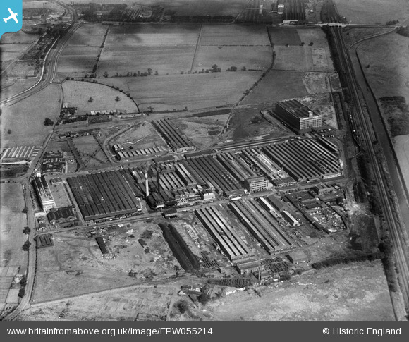
EPW055214 ENGLAND (1937). The Fort Dunlop Rubber Works, Bromford, 1937
© Copyright OpenStreetMap contributors and licensed by the OpenStreetMap Foundation. 2026. Cartography is licensed as CC BY-SA.
Nearby Images (18)
Details
| Title | [EPW055214] The Fort Dunlop Rubber Works, Bromford, 1937 |
| Reference | EPW055214 |
| Date | 4-September-1937 |
| Link | |
| Place name | BROMFORD |
| Parish | |
| District | |
| Country | ENGLAND |
| Easting / Northing | 412626, 290379 |
| Longitude / Latitude | -1.813940165925, 52.51078963758 |
| National Grid Reference | SP126904 |
Pins

Martin |
Monday 30th of December 2013 07:10:47 PM |


![[EPW055214] The Fort Dunlop Rubber Works, Bromford, 1937](http://britainfromabove.org.uk/sites/all/libraries/aerofilms-images/public/100x100/EPW/055/EPW055214.jpg)
![[EPW055216] The Fort Dunlop Rubber Works, Bromford, 1937](http://britainfromabove.org.uk/sites/all/libraries/aerofilms-images/public/100x100/EPW/055/EPW055216.jpg)
![[EPW026939] Fort Dunlop Rubber Works and Birmingham Racecourse, Bromford, 1929](http://britainfromabove.org.uk/sites/all/libraries/aerofilms-images/public/100x100/EPW/026/EPW026939.jpg)
![[EPW025791] Fort Dunlop Rubber Works, Bromford, 1929. This image has been produced from a print.](http://britainfromabove.org.uk/sites/all/libraries/aerofilms-images/public/100x100/EPW/025/EPW025791.jpg)
![[EPW026937] Fort Dunlop Rubber Works and Birmingham Racecourse, Bromford, 1929](http://britainfromabove.org.uk/sites/all/libraries/aerofilms-images/public/100x100/EPW/026/EPW026937.jpg)
![[EPW055215] The Fort Dunlop Rubber Works, Bromford, 1937](http://britainfromabove.org.uk/sites/all/libraries/aerofilms-images/public/100x100/EPW/055/EPW055215.jpg)
![[EPW055212] The Fort Dunlop Rubber Works, Bromford, from the south-west, 1937](http://britainfromabove.org.uk/sites/all/libraries/aerofilms-images/public/100x100/EPW/055/EPW055212.jpg)
![[EPW055211] The Fort Dunlop Rubber Works, Bromford, 1937](http://britainfromabove.org.uk/sites/all/libraries/aerofilms-images/public/100x100/EPW/055/EPW055211.jpg)
![[EPW026940] Fort Dunlop Rubber Works, Bromford, 1929](http://britainfromabove.org.uk/sites/all/libraries/aerofilms-images/public/100x100/EPW/026/EPW026940.jpg)
![[EPW055218] The Fort Dunlop Rubber Works, Bromford, from the south-east, 1937](http://britainfromabove.org.uk/sites/all/libraries/aerofilms-images/public/100x100/EPW/055/EPW055218.jpg)
![[EPW026934] Fort Dunlop Rubber Works and Birmingham Racecourse, Bromford, 1929](http://britainfromabove.org.uk/sites/all/libraries/aerofilms-images/public/100x100/EPW/026/EPW026934.jpg)
![[EPW026943] Fort Dunlop Rubber Works, Bromford, 1929](http://britainfromabove.org.uk/sites/all/libraries/aerofilms-images/public/100x100/EPW/026/EPW026943.jpg)
![[EPW055217] The Fort Dunlop Rubber Works, Bromford, from the south-east, 1937](http://britainfromabove.org.uk/sites/all/libraries/aerofilms-images/public/100x100/EPW/055/EPW055217.jpg)
![[EPW026936] Fort Dunlop Rubber Works, Bromford, 1929](http://britainfromabove.org.uk/sites/all/libraries/aerofilms-images/public/100x100/EPW/026/EPW026936.jpg)
![[EPW055213] The Fort Dunlop Rubber Works, Bromford, 1937](http://britainfromabove.org.uk/sites/all/libraries/aerofilms-images/public/100x100/EPW/055/EPW055213.jpg)
![[EPW022581] Fort Dunlop Rubber Works, Bromford, 1928](http://britainfromabove.org.uk/sites/all/libraries/aerofilms-images/public/100x100/EPW/022/EPW022581.jpg)
![[EPW001206] Rubber works and Birmingham Racecourse, Bromford, 1920](http://britainfromabove.org.uk/sites/all/libraries/aerofilms-images/public/100x100/EPW/001/EPW001206.jpg)
![[EPW055210] The Fort Dunlop Rubber Works, Bromford, 1937](http://britainfromabove.org.uk/sites/all/libraries/aerofilms-images/public/100x100/EPW/055/EPW055210.jpg)