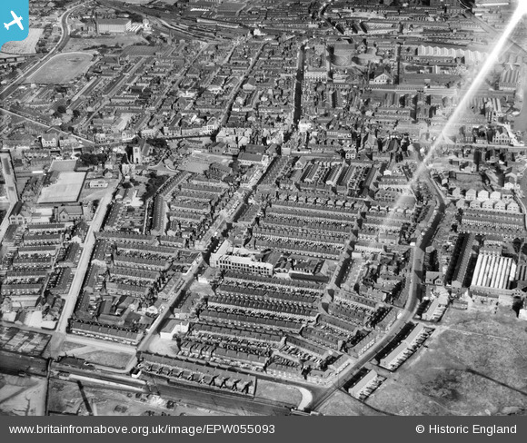
EPW055093 ENGLAND (1937). Railway Road and the town, Leigh, 1937
© Copyright OpenStreetMap contributors and licensed by the OpenStreetMap Foundation. 2026. Cartography is licensed as CC BY-SA.
Nearby Images (5)
Details
| Title | [EPW055093] Railway Road and the town, Leigh, 1937 |
| Reference | EPW055093 |
| Date | August-1937 |
| Link | |
| Place name | LEIGH |
| Parish | |
| District | |
| Country | ENGLAND |
| Easting / Northing | 365398, 400177 |
| Longitude / Latitude | -2.521659062307, 53.496904864214 |
| National Grid Reference | SD654002 |
Pins

LankyLass |
Wednesday 30th of April 2014 04:26:15 PM | |

LankyLass |
Wednesday 30th of April 2014 04:24:59 PM | |

LankyLass |
Wednesday 30th of April 2014 04:23:51 PM | |

LankyLass |
Wednesday 30th of April 2014 04:22:55 PM | |

LankyLass |
Wednesday 30th of April 2014 04:22:16 PM | |

Thomas W |
Sunday 13th of April 2014 03:00:20 AM | |

Thomas W |
Sunday 13th of April 2014 02:57:00 AM | |

Dave |
Monday 25th of November 2013 12:24:42 PM |


![[EPW055093] Railway Road and the town, Leigh, 1937](http://britainfromabove.org.uk/sites/all/libraries/aerofilms-images/public/100x100/EPW/055/EPW055093.jpg)
![[EPW055096] The town, Leigh, from the north-west, 1937](http://britainfromabove.org.uk/sites/all/libraries/aerofilms-images/public/100x100/EPW/055/EPW055096.jpg)
![[EPW031121] Cook Street and surroundings, Leigh, 1929](http://britainfromabove.org.uk/sites/all/libraries/aerofilms-images/public/100x100/EPW/031/EPW031121.jpg)
![[EPW031122] St Mary's Church, Leigh, 1929](http://britainfromabove.org.uk/sites/all/libraries/aerofilms-images/public/100x100/EPW/031/EPW031122.jpg)
![[EPW031118] The King Street Methodist Church and surroundings, Leigh, 1929](http://britainfromabove.org.uk/sites/all/libraries/aerofilms-images/public/100x100/EPW/031/EPW031118.jpg)