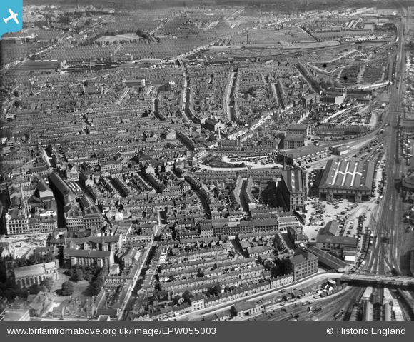
EPW055003 ENGLAND (1937). London Road Railway Goods Sheds off Humberstone Road and the city, Leicester, from the south-west 1937
© Copyright OpenStreetMap contributors and licensed by the OpenStreetMap Foundation. 2026. Cartography is licensed as CC BY-SA.
Nearby Images (7)
Details
| Title | [EPW055003] London Road Railway Goods Sheds off Humberstone Road and the city, Leicester, from the south-west 1937 |
| Reference | EPW055003 |
| Date | August-1937 |
| Link | |
| Place name | LEICESTER |
| Parish | |
| District | |
| Country | ENGLAND |
| Easting / Northing | 459367, 304473 |
| Longitude / Latitude | -1.1226810819191, 52.634405186828 |
| National Grid Reference | SK594045 |
Pins

mikeyp |
Friday 17th of February 2023 05:17:34 PM | |

mikeyp |
Friday 17th of February 2023 05:15:08 PM | |

mikeyp |
Friday 17th of February 2023 05:14:19 PM | |

davewig |
Tuesday 29th of September 2020 04:42:25 PM | |

davewig |
Tuesday 29th of September 2020 04:33:15 PM | |

davewig |
Tuesday 29th of September 2020 04:28:04 PM | |

davewig |
Tuesday 29th of September 2020 04:23:20 PM | |

gBr |
Thursday 5th of January 2017 10:10:52 PM | |

c j moon |
Friday 25th of April 2014 05:50:47 PM | |

c j moon |
Friday 25th of April 2014 05:49:12 PM |


![[EPW055003] London Road Railway Goods Sheds off Humberstone Road and the city, Leicester, from the south-west 1937](http://britainfromabove.org.uk/sites/all/libraries/aerofilms-images/public/100x100/EPW/055/EPW055003.jpg)
![[EPW018428] Queen Street, Leicester, 1927. This image has been produced from a print.](http://britainfromabove.org.uk/sites/all/libraries/aerofilms-images/public/100x100/EPW/018/EPW018428.jpg)
![[EPW018459] St George's Church and environs, Leicester, 1927. This image has been produced from a print.](http://britainfromabove.org.uk/sites/all/libraries/aerofilms-images/public/100x100/EPW/018/EPW018459.jpg)
![[EAW052677] Rutland Street and St George's Church, Leicester, 1953. This image was marked by Aerofilms Ltd for photo editing.](http://britainfromabove.org.uk/sites/all/libraries/aerofilms-images/public/100x100/EAW/052/EAW052677.jpg)
![[EAW052678] Colton Street and Arthur Foister and Sons Ltd (Cherub Ltd) Factory on Charles Street, Leicester, 1953. This image was marked by Aerofilms Ltd for photo editing.](http://britainfromabove.org.uk/sites/all/libraries/aerofilms-images/public/100x100/EAW/052/EAW052678.jpg)
![[EAW052681] Arthur Foister and Sons Ltd (Cherub Ltd) Factory on Charles Street and St George's Church, Leicester, 1953. This image was marked by Aerofilms Ltd for photo editing.](http://britainfromabove.org.uk/sites/all/libraries/aerofilms-images/public/100x100/EAW/052/EAW052681.jpg)
![[EAW052679] Colton Street and Arthur Foister and Sons Ltd (Cherub Ltd) Factory on Charles Street, Leicester, 1953. This image was marked by Aerofilms Ltd for photo editing.](http://britainfromabove.org.uk/sites/all/libraries/aerofilms-images/public/100x100/EAW/052/EAW052679.jpg)