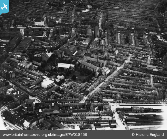
EPW018459 ENGLAND (1927). St George's Church and environs, Leicester, 1927. This image has been produced from a print.
© Copyright OpenStreetMap contributors and licensed by the OpenStreetMap Foundation. 2026. Cartography is licensed as CC BY-SA.
Nearby Images (19)
Details
| Title | [EPW018459] St George's Church and environs, Leicester, 1927. This image has been produced from a print. |
| Reference | EPW018459 |
| Date | June-1927 |
| Link | |
| Place name | LEICESTER |
| Parish | |
| District | |
| Country | ENGLAND |
| Easting / Northing | 459238, 304444 |
| Longitude / Latitude | -1.1245923909469, 52.634158583581 |
| National Grid Reference | SK592044 |
Pins
Be the first to add a comment to this image!


![[EPW018459] St George's Church and environs, Leicester, 1927. This image has been produced from a print.](http://britainfromabove.org.uk/sites/all/libraries/aerofilms-images/public/100x100/EPW/018/EPW018459.jpg)
![[EPW018428] Queen Street, Leicester, 1927. This image has been produced from a print.](http://britainfromabove.org.uk/sites/all/libraries/aerofilms-images/public/100x100/EPW/018/EPW018428.jpg)
![[EAW052677] Rutland Street and St George's Church, Leicester, 1953. This image was marked by Aerofilms Ltd for photo editing.](http://britainfromabove.org.uk/sites/all/libraries/aerofilms-images/public/100x100/EAW/052/EAW052677.jpg)
![[EAW052681] Arthur Foister and Sons Ltd (Cherub Ltd) Factory on Charles Street and St George's Church, Leicester, 1953. This image was marked by Aerofilms Ltd for photo editing.](http://britainfromabove.org.uk/sites/all/libraries/aerofilms-images/public/100x100/EAW/052/EAW052681.jpg)
![[EAW052678] Colton Street and Arthur Foister and Sons Ltd (Cherub Ltd) Factory on Charles Street, Leicester, 1953. This image was marked by Aerofilms Ltd for photo editing.](http://britainfromabove.org.uk/sites/all/libraries/aerofilms-images/public/100x100/EAW/052/EAW052678.jpg)
![[EAW052679] Colton Street and Arthur Foister and Sons Ltd (Cherub Ltd) Factory on Charles Street, Leicester, 1953. This image was marked by Aerofilms Ltd for photo editing.](http://britainfromabove.org.uk/sites/all/libraries/aerofilms-images/public/100x100/EAW/052/EAW052679.jpg)
![[EPW055003] London Road Railway Goods Sheds off Humberstone Road and the city, Leicester, from the south-west 1937](http://britainfromabove.org.uk/sites/all/libraries/aerofilms-images/public/100x100/EPW/055/EPW055003.jpg)
![[EAW052674] Arthur Foister & Sons Ltd (Cherub Ltd) Factory on Charles Street, St George's Church and Rutland Street, Leicester, 1953. This image was marked by Aerofilms Ltd for photo editing.](http://britainfromabove.org.uk/sites/all/libraries/aerofilms-images/public/100x100/EAW/052/EAW052674.jpg)
![[EAW052675] Arthur Foister & Sons Ltd (Cherub Ltd) Factory on Charles Street, Leicester, 1953. This image was marked by Aerofilms Ltd for photo editing.](http://britainfromabove.org.uk/sites/all/libraries/aerofilms-images/public/100x100/EAW/052/EAW052675.jpg)
![[EAW052676] Arthur Foister & Sons Ltd (Cherub Ltd) Factory on Charles Street and St George's Church, Leicester, 1953. This image was marked by Aerofilms Ltd for photo editing.](http://britainfromabove.org.uk/sites/all/libraries/aerofilms-images/public/100x100/EAW/052/EAW052676.jpg)
![[EAW052680] Arthur Foister and Sons Ltd (Cherub Ltd) Factory on Charles Street, Leicester, 1953. This image was marked by Aerofilms Ltd for photo editing.](http://britainfromabove.org.uk/sites/all/libraries/aerofilms-images/public/100x100/EAW/052/EAW052680.jpg)
![[EPW055009] Charles Street, St George's Church and the city, Leicester, 1937](http://britainfromabove.org.uk/sites/all/libraries/aerofilms-images/public/100x100/EPW/055/EPW055009.jpg)
![[EPW055002] The city around Belvoir Street and Granby Street, Leicester, 1937](http://britainfromabove.org.uk/sites/all/libraries/aerofilms-images/public/100x100/EPW/055/EPW055002.jpg)
![[EAW052689] Arthur Foister and Sons Ltd (Cherub Ltd) Factory on Campbell Street and London Road Railway Station, Leicester, 1953. This image was marked by Aerofilms Ltd for photo editing.](http://britainfromabove.org.uk/sites/all/libraries/aerofilms-images/public/100x100/EAW/052/EAW052689.jpg)
![[EPW061213] Charles Street and environs, Leicester, 1939](http://britainfromabove.org.uk/sites/all/libraries/aerofilms-images/public/100x100/EPW/061/EPW061213.jpg)
![[EAW052687] Arthur Foister and Sons Ltd (Cherub Ltd) Factory on Campbell Street and London Road Railway Station, Leicester, 1953. This image was marked by Aerofilms Ltd for photo editing.](http://britainfromabove.org.uk/sites/all/libraries/aerofilms-images/public/100x100/EAW/052/EAW052687.jpg)
![[EAW052688] Arthur Foister and Sons Ltd (Cherub Ltd) Factory on Campbell Street and London Road Railway Station, Leicester, 1953. This image was marked by Aerofilms Ltd for photo editing.](http://britainfromabove.org.uk/sites/all/libraries/aerofilms-images/public/100x100/EAW/052/EAW052688.jpg)
![[EAW052686] Arthur Foister and Sons Ltd (Cherub Ltd) Factory on Campbell Street and London Road Railway Station, Leicester, 1953. This image was marked by Aerofilms Ltd for photo editing.](http://britainfromabove.org.uk/sites/all/libraries/aerofilms-images/public/100x100/EAW/052/EAW052686.jpg)
![[EAW052683] Arthur Foister and Sons Ltd (Cherub Ltd) Factory on Campbell Street and London Road Railway Station, Leicester, 1953. This image was marked by Aerofilms Ltd for photo editing.](http://britainfromabove.org.uk/sites/all/libraries/aerofilms-images/public/100x100/EAW/052/EAW052683.jpg)