
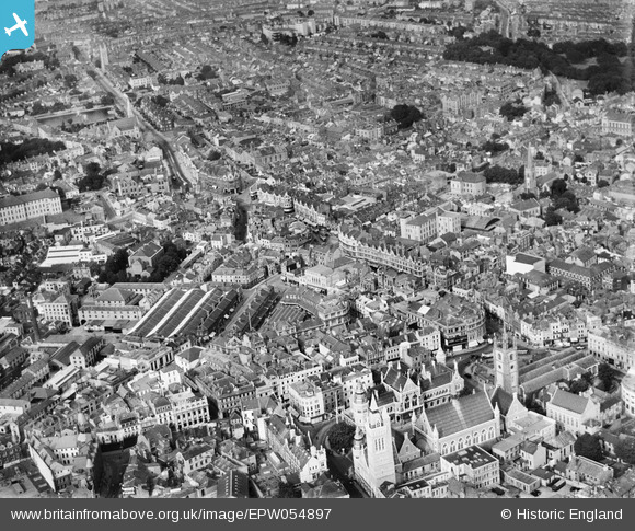
EPW054897 ENGLAND (1937). Old Town Street and environs, Plymouth, 1937
© Copyright OpenStreetMap contributors and licensed by the OpenStreetMap Foundation. 2026. Cartography is licensed as CC BY-SA.
Nearby Images (8)
EPW054897

EPW011281

EPW054888

EPW011258

EPW054886

EPW011257

EAW051365

EAW007572

Details
| Title | [EPW054897] Old Town Street and environs, Plymouth, 1937 |
| Reference | EPW054897 |
| Date | 16-August-1937 |
| Link | |
| Place name | PLYMOUTH |
| Parish | |
| District | |
| Country | ENGLAND |
| Easting / Northing | 247973, 54628 |
| Longitude / Latitude | -4.138100070001, 50.371271010999 |
| National Grid Reference | SX480546 |
Pins

Wombateer |
Friday 12th of June 2020 08:30:26 PM | |
|
flyman |
Monday 25th of March 2019 09:44:48 PM | |
|
flyman |
Monday 25th of March 2019 09:43:51 PM | |

Class31 |
Friday 17th of April 2015 08:01:21 AM | |
|
Class31 |
Friday 17th of April 2015 07:59:59 AM | |
|
Class31 |
Friday 17th of April 2015 07:58:11 AM | |
|
Class31 |
Friday 17th of April 2015 07:55:59 AM | |
|
Class31 |
Friday 17th of April 2015 07:54:40 AM | |
|
Class31 |
Friday 17th of April 2015 07:53:34 AM | |
|
Class31 |
Friday 17th of April 2015 07:52:55 AM | |
|
Class31 |
Thursday 31st of October 2013 08:50:03 PM | |
I don't think so. This is Coburg Street. This was Public Secondary School when I was there from 1958 -1963. The Telephone Exchange is near Charles Church. |
JM@Home |
Friday 17th of October 2014 10:37:56 PM |
Apologies for the error and thanks to JM@Home for the correction. |
Class31 |
Friday 17th of April 2015 07:40:55 AM |


User Comment Contributions
We are looking north. I had previously wrongly said that the photo was looking south west! I always take great care with my identifications but this was not one of my best efforts. I shall now put that right. |
Class31 |
Friday 17th of April 2015 07:51:43 AM |
I have gained the impression that not much of what we see survived the World War II blitz. This photo would repay a more detailed examination. |
Class31 |
Thursday 31st of October 2013 09:03:40 PM |