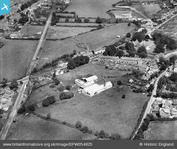
EPW054825 ENGLAND (1937). Milk Factory at the site of Asker Mills, Bridport, 1937
© Copyright OpenStreetMap contributors and licensed by the OpenStreetMap Foundation. 2026. Cartography is licensed as CC BY-SA.
Nearby Images (6)
Details
| Title | [EPW054825] Milk Factory at the site of Asker Mills, Bridport, 1937 |
| Reference | EPW054825 |
| Date | August-1937 |
| Link | |
| Place name | BRIDPORT |
| Parish | BRIDPORT |
| District | |
| Country | ENGLAND |
| Easting / Northing | 347229, 92827 |
| Longitude / Latitude | -2.7478271963158, 50.732087077953 |
| National Grid Reference | SY472928 |
Pins

vof |
Saturday 24th of August 2013 12:17:01 AM | |

vof |
Saturday 24th of August 2013 12:15:51 AM | |

vof |
Saturday 24th of August 2013 12:05:23 AM | |

vof |
Saturday 24th of August 2013 12:01:43 AM | |

vof |
Saturday 24th of August 2013 12:00:16 AM |


![[EPW054825] Milk Factory at the site of Asker Mills, Bridport, 1937](http://britainfromabove.org.uk/sites/all/libraries/aerofilms-images/public/100x100/EPW/054/EPW054825.jpg)
![[EPW054822] Milk Factory at the site of Asker Mills, Bridport, 1937](http://britainfromabove.org.uk/sites/all/libraries/aerofilms-images/public/100x100/EPW/054/EPW054822.jpg)
![[EPW054823] Milk Factory at the site of Asker Mills, Bridport, 1937](http://britainfromabove.org.uk/sites/all/libraries/aerofilms-images/public/100x100/EPW/054/EPW054823.jpg)
![[EPW054827] Milk Factory at the site of Asker Mills, Bridport, 1937](http://britainfromabove.org.uk/sites/all/libraries/aerofilms-images/public/100x100/EPW/054/EPW054827.jpg)
![[EPW054824] Milk Factory at the site of Asker Mills, Bridport, 1937](http://britainfromabove.org.uk/sites/all/libraries/aerofilms-images/public/100x100/EPW/054/EPW054824.jpg)
![[EPW054826] Milk Factory at the site of Asker Mills, Bothenhampton, 1937](http://britainfromabove.org.uk/sites/all/libraries/aerofilms-images/public/100x100/EPW/054/EPW054826.jpg)