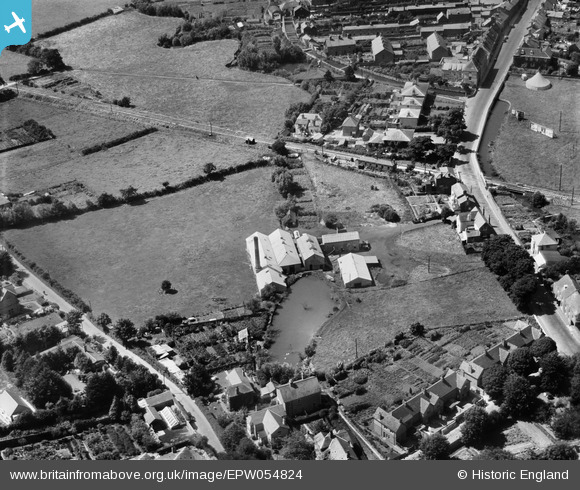
EPW054824 ENGLAND (1937). Milk Factory at the site of Asker Mills, Bridport, 1937
© Copyright OpenStreetMap contributors and licensed by the OpenStreetMap Foundation. 2026. Cartography is licensed as CC BY-SA.
Nearby Images (6)
Details
| Title | [EPW054824] Milk Factory at the site of Asker Mills, Bridport, 1937 |
| Reference | EPW054824 |
| Date | August-1937 |
| Link | |
| Place name | BRIDPORT |
| Parish | BRIDPORT |
| District | |
| Country | ENGLAND |
| Easting / Northing | 347190, 92770 |
| Longitude / Latitude | -2.7483716540662, 50.731570935835 |
| National Grid Reference | SY472928 |
Pins

clippedwings |
Monday 3rd of February 2014 10:26:12 AM |
User Comment Contributions
A fantastic shot of Bridport East Street Railway Station. |

Class31 |
Monday 3rd of February 2014 10:02:43 AM |


![[EPW054824] Milk Factory at the site of Asker Mills, Bridport, 1937](http://britainfromabove.org.uk/sites/all/libraries/aerofilms-images/public/100x100/EPW/054/EPW054824.jpg)
![[EPW054826] Milk Factory at the site of Asker Mills, Bothenhampton, 1937](http://britainfromabove.org.uk/sites/all/libraries/aerofilms-images/public/100x100/EPW/054/EPW054826.jpg)
![[EPW054827] Milk Factory at the site of Asker Mills, Bridport, 1937](http://britainfromabove.org.uk/sites/all/libraries/aerofilms-images/public/100x100/EPW/054/EPW054827.jpg)
![[EPW054822] Milk Factory at the site of Asker Mills, Bridport, 1937](http://britainfromabove.org.uk/sites/all/libraries/aerofilms-images/public/100x100/EPW/054/EPW054822.jpg)
![[EPW054823] Milk Factory at the site of Asker Mills, Bridport, 1937](http://britainfromabove.org.uk/sites/all/libraries/aerofilms-images/public/100x100/EPW/054/EPW054823.jpg)
![[EPW054825] Milk Factory at the site of Asker Mills, Bridport, 1937](http://britainfromabove.org.uk/sites/all/libraries/aerofilms-images/public/100x100/EPW/054/EPW054825.jpg)