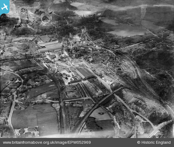
EPW052969 ENGLAND (1937). The Thorncliffe Iron Works and Colliery, Chapeltown, 1937. This image has been produced from a damaged negative.
© Copyright OpenStreetMap contributors and licensed by the OpenStreetMap Foundation. 2026. Cartography is licensed as CC BY-SA.
Nearby Images (6)
Details
| Title | [EPW052969] The Thorncliffe Iron Works and Colliery, Chapeltown, 1937. This image has been produced from a damaged negative. |
| Reference | EPW052969 |
| Date | 6-May-1937 |
| Link | |
| Place name | CHAPELTOWN |
| Parish | ECCLESFIELD |
| District | |
| Country | ENGLAND |
| Easting / Northing | 435221, 397254 |
| Longitude / Latitude | -1.4693373538604, 53.47058863717 |
| National Grid Reference | SK352973 |
Pins
Be the first to add a comment to this image!


![[EPW052969] The Thorncliffe Iron Works and Colliery, Chapeltown, 1937. This image has been produced from a damaged negative.](http://britainfromabove.org.uk/sites/all/libraries/aerofilms-images/public/100x100/EPW/052/EPW052969.jpg)
![[EPW052970] The Thorncliffe Iron Works and Colliery, Chapeltown, 1937](http://britainfromabove.org.uk/sites/all/libraries/aerofilms-images/public/100x100/EPW/052/EPW052970.jpg)
![[EPW052972] The Thorncliffe Iron Works and Colliery, Chapeltown, 1937](http://britainfromabove.org.uk/sites/all/libraries/aerofilms-images/public/100x100/EPW/052/EPW052972.jpg)
![[EPW052967] The Thorncliffe Iron Works and Colliery, Chapeltown, 1937](http://britainfromabove.org.uk/sites/all/libraries/aerofilms-images/public/100x100/EPW/052/EPW052967.jpg)
![[EPW052968] The Thorncliffe Iron Works and Colliery, Chapeltown, 1937. This image has been produced from a damaged negative.](http://britainfromabove.org.uk/sites/all/libraries/aerofilms-images/public/100x100/EPW/052/EPW052968.jpg)
![[EPW015483] Thorncliffe Iron Works and Thorncliffe Colliery, Chapeltown, 1926](http://britainfromabove.org.uk/sites/all/libraries/aerofilms-images/public/100x100/EPW/015/EPW015483.jpg)