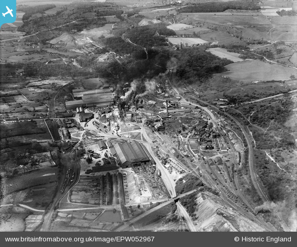
EPW052967 ENGLAND (1937). The Thorncliffe Iron Works and Colliery, Chapeltown, 1937
© Copyright OpenStreetMap contributors and licensed by the OpenStreetMap Foundation. 2026. Cartography is licensed as CC BY-SA.
Nearby Images (7)
Details
| Title | [EPW052967] The Thorncliffe Iron Works and Colliery, Chapeltown, 1937 |
| Reference | EPW052967 |
| Date | 6-May-1937 |
| Link | |
| Place name | CHAPELTOWN |
| Parish | ECCLESFIELD |
| District | |
| Country | ENGLAND |
| Easting / Northing | 435084, 397458 |
| Longitude / Latitude | -1.471378602313, 53.472431565744 |
| National Grid Reference | SK351975 |
Pins

tlelliott77 |
Tuesday 17th of March 2015 10:43:05 PM | |

tlelliott77 |
Tuesday 17th of March 2015 10:42:31 PM |


![[EPW052967] The Thorncliffe Iron Works and Colliery, Chapeltown, 1937](http://britainfromabove.org.uk/sites/all/libraries/aerofilms-images/public/100x100/EPW/052/EPW052967.jpg)
![[EPW052968] The Thorncliffe Iron Works and Colliery, Chapeltown, 1937. This image has been produced from a damaged negative.](http://britainfromabove.org.uk/sites/all/libraries/aerofilms-images/public/100x100/EPW/052/EPW052968.jpg)
![[EPW015483] Thorncliffe Iron Works and Thorncliffe Colliery, Chapeltown, 1926](http://britainfromabove.org.uk/sites/all/libraries/aerofilms-images/public/100x100/EPW/015/EPW015483.jpg)
![[EPW015482] Thorncliffe Iron Works and Thorncliffe Colliery, Chapeltown, 1926](http://britainfromabove.org.uk/sites/all/libraries/aerofilms-images/public/100x100/EPW/015/EPW015482.jpg)
![[EPW052972] The Thorncliffe Iron Works and Colliery, Chapeltown, 1937](http://britainfromabove.org.uk/sites/all/libraries/aerofilms-images/public/100x100/EPW/052/EPW052972.jpg)
![[EPW052969] The Thorncliffe Iron Works and Colliery, Chapeltown, 1937. This image has been produced from a damaged negative.](http://britainfromabove.org.uk/sites/all/libraries/aerofilms-images/public/100x100/EPW/052/EPW052969.jpg)
![[EPW052970] The Thorncliffe Iron Works and Colliery, Chapeltown, 1937](http://britainfromabove.org.uk/sites/all/libraries/aerofilms-images/public/100x100/EPW/052/EPW052970.jpg)