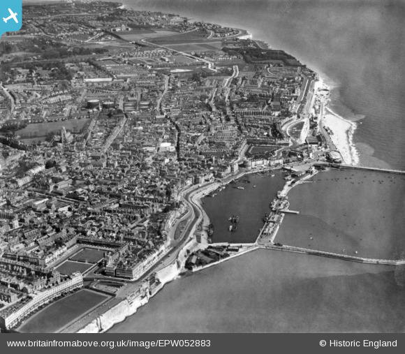
EPW052883 ENGLAND (1937). The town and seafront, Ramsgate, 1937. This image has been produced from a print.
    © Copyright OpenStreetMap contributors and licensed by the OpenStreetMap Foundation. 2025. Cartography is licensed as CC BY-SA.
  
Nearby Images (9)
Details
| Title | [EPW052883] The town and seafront, Ramsgate, 1937. This image has been produced from a print. | 
| Reference | EPW052883 | 
| Date | 24-May-1937 | 
| Link | |
| Place name | RAMSGATE | 
| Parish | RAMSGATE | 
| District | |
| Country | ENGLAND | 
| Easting / Northing | 638217, 164865 | 
| Longitude / Latitude | 1.4201362742428, 51.33238845354 | 
| National Grid Reference | TR382649 | 
Pins
|   Alan McFaden | Saturday 15th of November 2014 10:35:00 AM | |
|   Alan McFaden | Saturday 15th of November 2014 10:34:24 AM | |
|   Alan McFaden | Saturday 15th of November 2014 10:33:38 AM | |
|   Alan McFaden | Saturday 15th of November 2014 10:33:05 AM | |
|   Alan McFaden | Saturday 15th of November 2014 10:32:29 AM | |
|   Alan McFaden | Saturday 15th of November 2014 10:31:49 AM | 
 
             
  ![[EPW052883] The town and seafront, Ramsgate, 1937. This image has been produced from a print.](http://britainfromabove.org.uk/sites/all/libraries/aerofilms-images/public/100x100/EPW/052/EPW052883.jpg) 
  
                                          ![[EPW035452] The Royal Parade and the town centre, Ramsgate, 1931](http://britainfromabove.org.uk/sites/all/libraries/aerofilms-images/public/100x100/EPW/035/EPW035452.jpg) 
 ![[EPW052884] The town, Ramsgate, 1937. This image has been produced from a print.](http://britainfromabove.org.uk/sites/all/libraries/aerofilms-images/public/100x100/EPW/052/EPW052884.jpg) 
 ![[EPW000604] The Basin, Ramsgate, from the north-east, 1920](http://britainfromabove.org.uk/sites/all/libraries/aerofilms-images/public/100x100/EPW/000/EPW000604.jpg) 
 ![[EAW015835] The town and seafront, Ramsgate, 1948. This image has been produced from a print.](http://britainfromabove.org.uk/sites/all/libraries/aerofilms-images/public/100x100/EAW/015/EAW015835.jpg) 
 ![[EAW006164] The Basin, Harbour Parade and environs, Ramsgate, 1947](http://britainfromabove.org.uk/sites/all/libraries/aerofilms-images/public/100x100/EAW/006/EAW006164.jpg) 
 ![[EPW018645] St George's Church and the town, Ramsgate, 1927](http://britainfromabove.org.uk/sites/all/libraries/aerofilms-images/public/100x100/EPW/018/EPW018645.jpg) 
 ![[EAW006165] The Basin, Harbour Parade and environs, Ramsgate, 1947](http://britainfromabove.org.uk/sites/all/libraries/aerofilms-images/public/100x100/EAW/006/EAW006165.jpg) 
 ![[EAW015836] Royal Harbour, Ramsgate, 1948. This image has been produced from a print.](http://britainfromabove.org.uk/sites/all/libraries/aerofilms-images/public/100x100/EAW/015/EAW015836.jpg) 
 
 Wellington Cresent Area
 Wellington Cresent Area


