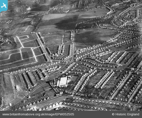
EPW052505 ENGLAND (1937). Residential development around Little Heath Road, Bexleyheath, 1937. This image has been produced from a print.
© Copyright OpenStreetMap contributors and licensed by the OpenStreetMap Foundation. 2026. Cartography is licensed as CC BY-SA.
Details
| Title | [EPW052505] Residential development around Little Heath Road, Bexleyheath, 1937. This image has been produced from a print. |
| Reference | EPW052505 |
| Date | 27-February-1937 |
| Link | |
| Place name | BEXLEYHEATH |
| Parish | |
| District | |
| Country | ENGLAND |
| Easting / Northing | 548528, 176973 |
| Longitude / Latitude | 0.13877267357563, 51.47171278884 |
| National Grid Reference | TQ485770 |
Pins

SUBHCMole |
Friday 14th of January 2022 05:46:07 PM | |

Don65 |
Thursday 7th of May 2020 03:09:34 PM | |

Jim Lawson |
Friday 31st of January 2020 03:10:56 PM | |

Peter D |
Saturday 21st of November 2015 05:46:13 PM | |

Peter D |
Saturday 21st of November 2015 05:45:29 PM | |

Peter D |
Saturday 21st of November 2015 05:42:44 PM | |

Peter D |
Saturday 21st of November 2015 05:42:04 PM | |

Peter D |
Saturday 21st of November 2015 05:41:10 PM | |

Peter D |
Saturday 21st of November 2015 05:39:36 PM | |

Barney |
Tuesday 7th of April 2015 07:22:05 AM | |

Dave L |
Sunday 8th of February 2015 05:33:09 PM | |

Dave L |
Sunday 8th of February 2015 05:32:32 PM |


![[EPW052505] Residential development around Little Heath Road, Bexleyheath, 1937. This image has been produced from a print.](http://britainfromabove.org.uk/sites/all/libraries/aerofilms-images/public/100x100/EPW/052/EPW052505.jpg)
![[EPW052502] Residential development to the south of Lesnes Abbey Woods, Bexleyheath, 1937. This image has been produced from a print.](http://britainfromabove.org.uk/sites/all/libraries/aerofilms-images/public/100x100/EPW/052/EPW052502.jpg)
