
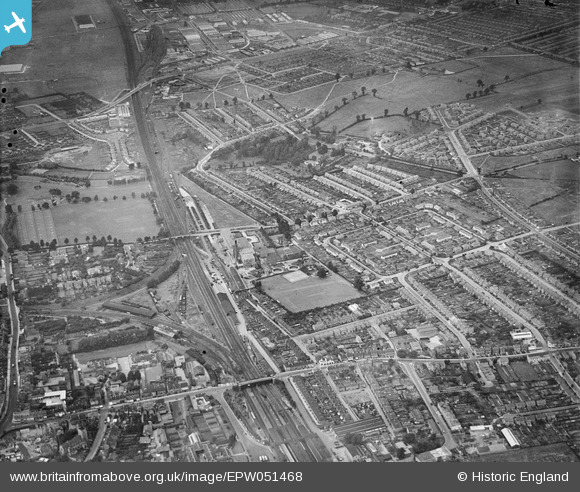
EPW051468 ENGLAND (1936). The Horlicks Factory and surrounding housing development, Slough, 1936
© Copyright OpenStreetMap contributors and licensed by the OpenStreetMap Foundation. 2026. Cartography is licensed as CC BY-SA.
Nearby Images (27)
EPW051468

EPW031608

EPW021893

EPW031606

EPW021892

EPW031198

EPW031193

EPW031197

EPW008010

EPW021889

EPW031195

EPW031196

EPW031194

EPW021788

EPW021891

EPW031603

EPW021895

EPW021787

EPW021789

EPW021896

EPW021790

EPW021785

EPW031607

EPW021894

EPW021786

EPW021890

EPW021888

Details
| Title | [EPW051468] The Horlicks Factory and surrounding housing development, Slough, 1936 |
| Reference | EPW051468 |
| Date | August-1936 |
| Link | |
| Place name | SLOUGH |
| Parish | |
| District | |
| Country | ENGLAND |
| Easting / Northing | 497258, 180537 |
| Longitude / Latitude | -0.5982223004219, 51.514892582452 |
| National Grid Reference | SU973805 |
Pins

Mike Holder |
Tuesday 30th of January 2018 03:34:55 PM | |
|
Mike Holder |
Tuesday 30th of January 2018 03:34:29 PM | |
 |

Class31 |
Tuesday 16th of July 2013 10:09:07 PM |
In the 60s I saw a concert with Cilla Black (who sang 'Anyone who had a heart'), Gene Pitney and some other pop groups of the time. I think one group may have been The Swinging Blue Jeans. I'd love to know who else played that evening as my memory fails me as to who else was on the bill. |
triciab |
Tuesday 31st of March 2015 07:02:15 PM |
|
Class31 |
Wednesday 3rd of July 2013 09:09:26 PM | |
|
Class31 |
Wednesday 3rd of July 2013 07:31:07 PM | |
|
Class31 |
Wednesday 3rd of July 2013 07:09:31 PM | |
|
Class31 |
Wednesday 3rd of July 2013 07:00:19 PM | |
|
payitforwardeddie |
Wednesday 29th of May 2013 06:20:43 AM | |
|
Mike Holder |
Sunday 19th of May 2013 02:32:50 PM | |
|
Mike Holder |
Sunday 19th of May 2013 02:25:40 PM | |
|
Mike Holder |
Sunday 19th of May 2013 02:23:12 PM | |
|
Mike Holder |
Sunday 19th of May 2013 02:18:55 PM | |
|
Mike Holder |
Sunday 19th of May 2013 02:17:47 PM | |
|
Mike Holder |
Saturday 18th of May 2013 03:16:11 PM | |
|
Mike Holder |
Saturday 18th of May 2013 03:09:42 PM | |
|
Mike Holder |
Saturday 18th of May 2013 03:08:25 PM | |
|
Mike Holder |
Saturday 18th of May 2013 03:05:54 PM | |
|
Mike Holder |
Saturday 18th of May 2013 03:01:57 PM | |
|
Mike Holder |
Saturday 18th of May 2013 02:57:57 PM | |
They also had a football pitch on this site, I remember watching a Sunday league match that included players that played for Slough Town FC in the Armature Cup Final at Wembley Stadium. |
fulham rebel |
Thursday 16th of June 2016 10:15:03 AM |
|
Mike Holder |
Saturday 18th of May 2013 02:54:36 PM | |
|
Mike Holder |
Saturday 18th of May 2013 02:51:07 PM | |
|
dave43 |
Tuesday 14th of May 2013 08:21:10 PM | |
|
dave43 |
Tuesday 14th of May 2013 08:20:34 PM | |
|
dave43 |
Tuesday 14th of May 2013 08:20:06 PM | |
|
dave43 |
Tuesday 14th of May 2013 08:18:59 PM |
User Comment Contributions
View looking west. |
Class31 |
Wednesday 3rd of July 2013 08:41:20 PM |