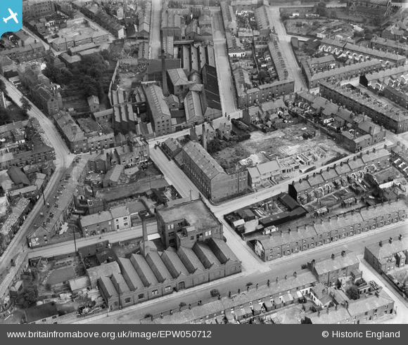
EPW050712 ENGLAND (1936). The Henderson Street Silk Mill and the Bond Street Silk Mill, Macclesfield, 1936
© Copyright OpenStreetMap contributors and licensed by the OpenStreetMap Foundation. 2026. Cartography is licensed as CC BY-SA.
Nearby Images (15)
Details
| Title | [EPW050712] The Henderson Street Silk Mill and the Bond Street Silk Mill, Macclesfield, 1936 |
| Reference | EPW050712 |
| Date | June-1936 |
| Link | |
| Place name | MACCLESFIELD |
| Parish | |
| District | |
| Country | ENGLAND |
| Easting / Northing | 391374, 373392 |
| Longitude / Latitude | -2.1293166897201, 53.257185308771 |
| National Grid Reference | SJ914734 |
Pins

jonnyhud |
Monday 1st of February 2016 05:49:46 PM | |

jonnyhud |
Monday 1st of February 2016 05:46:00 PM | |

jonnyhud |
Monday 1st of February 2016 05:45:01 PM | |

jonnyhud |
Monday 1st of February 2016 05:41:28 PM | |

jonnyhud |
Monday 1st of February 2016 05:29:43 PM | |

Charles Dale |
Friday 17th of July 2015 10:25:54 PM |


![[EPW050712] The Henderson Street Silk Mill and the Bond Street Silk Mill, Macclesfield, 1936](http://britainfromabove.org.uk/sites/all/libraries/aerofilms-images/public/100x100/EPW/050/EPW050712.jpg)
![[EPW050713] The Henderson Street Silk Mill and the surrounding residential area, Macclesfield, 1936](http://britainfromabove.org.uk/sites/all/libraries/aerofilms-images/public/100x100/EPW/050/EPW050713.jpg)
![[EPW050716] The Henderson Street Silk Mill and the Bond Street Silk Mill, Macclesfield, 1936](http://britainfromabove.org.uk/sites/all/libraries/aerofilms-images/public/100x100/EPW/050/EPW050716.jpg)
![[EPW050714] The Henderson Street Silk Mill and the surrounding residential area, Macclesfield, 1936. This image has been produced from a damaged negative.](http://britainfromabove.org.uk/sites/all/libraries/aerofilms-images/public/100x100/EPW/050/EPW050714.jpg)
![[EPW050711] The Henderson Street Silk Mill and the surrounding residential area, Macclesfield, 1936](http://britainfromabove.org.uk/sites/all/libraries/aerofilms-images/public/100x100/EPW/050/EPW050711.jpg)
![[EPW050715] The Henderson Street Silk Mill and the surrounding residential area, Macclesfield, 1936](http://britainfromabove.org.uk/sites/all/libraries/aerofilms-images/public/100x100/EPW/050/EPW050715.jpg)
![[EPW016738] Crossall Street and environs, Macclesfield, 1926. This image has been produced from a damaged copy-negative.](http://britainfromabove.org.uk/sites/all/libraries/aerofilms-images/public/100x100/EPW/016/EPW016738.jpg)
![[EAW018050] Silk Mill on Elizabeth Street, Macclesfield, 1948. This image was marked by Aerofilms Ltd for photo editing.](http://britainfromabove.org.uk/sites/all/libraries/aerofilms-images/public/100x100/EAW/018/EAW018050.jpg)
![[EAW018055] Silk Mill on Elizabeth Street, Macclesfield, 1948. This image was marked by Aerofilms Ltd for photo editing.](http://britainfromabove.org.uk/sites/all/libraries/aerofilms-images/public/100x100/EAW/018/EAW018055.jpg)
![[EAW018053] Silk Mill on Elizabeth Street, Macclesfield, 1948. This image was marked by Aerofilms Ltd for photo editing.](http://britainfromabove.org.uk/sites/all/libraries/aerofilms-images/public/100x100/EAW/018/EAW018053.jpg)
![[EAW018052] Silk Mill on Elizabeth Street, Macclesfield, 1948. This image was marked by Aerofilms Ltd for photo editing.](http://britainfromabove.org.uk/sites/all/libraries/aerofilms-images/public/100x100/EAW/018/EAW018052.jpg)
![[EAW018051] Silk Mill on Elizabeth Street, Macclesfield, 1948. This image was marked by Aerofilms Ltd for photo editing.](http://britainfromabove.org.uk/sites/all/libraries/aerofilms-images/public/100x100/EAW/018/EAW018051.jpg)
![[EAW018054] Silk Mill on Elizabeth Street, Macclesfield, 1948. This image was marked by Aerofilms Ltd for photo editing.](http://britainfromabove.org.uk/sites/all/libraries/aerofilms-images/public/100x100/EAW/018/EAW018054.jpg)
![[EAW018049] Silk Mill on Elizabeth Street, Macclesfield, 1948. This image was marked by Aerofilms Ltd for photo editing.](http://britainfromabove.org.uk/sites/all/libraries/aerofilms-images/public/100x100/EAW/018/EAW018049.jpg)
![[EAW018056] Silk Mill on Elizabeth Street, Macclesfield, 1948. This image was marked by Aerofilms Ltd for photo editing.](http://britainfromabove.org.uk/sites/all/libraries/aerofilms-images/public/100x100/EAW/018/EAW018056.jpg)