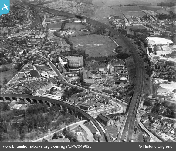
EPW049823 ENGLAND (1936). The London, Midland & Scottish Railway (LMSR) Bushey Curve, the High Street and environs, Watford, 1936
    © Copyright OpenStreetMap contributors and licensed by the OpenStreetMap Foundation. 2025. Cartography is licensed as CC BY-SA.
  
Nearby Images (9)
Details
| Title | [EPW049823] The London, Midland & Scottish Railway (LMSR) Bushey Curve, the High Street and environs, Watford, 1936 | 
| Reference | EPW049823 | 
| Date | May-1936 | 
| Link | |
| Place name | WATFORD | 
| Parish | |
| District | |
| Country | ENGLAND | 
| Easting / Northing | 511771, 195721 | 
| Longitude / Latitude | -0.38429577604775, 51.648693354099 | 
| National Grid Reference | TQ118957 | 
 
             
  ![[EPW049823] The London, Midland & Scottish Railway (LMSR) Bushey Curve, the High Street and environs, Watford, 1936](http://britainfromabove.org.uk/sites/all/libraries/aerofilms-images/public/100x100/EPW/049/EPW049823.jpg) 
  
                                          ![[EPW049818] The London, Midland & Scottish Railway (LMSR) Bushey Curve, the High Street and environs, Watford, from the south-west, 1936](http://britainfromabove.org.uk/sites/all/libraries/aerofilms-images/public/100x100/EPW/049/EPW049818.jpg) 
 ![[EPW049825] Gas Works adjacent to the London, Midland & Scottish Railway (LMSR) Bushey Curve and environs, Watford, 1936](http://britainfromabove.org.uk/sites/all/libraries/aerofilms-images/public/100x100/EPW/049/EPW049825.jpg) 
 ![[EPW049813] The LMSR Bushey Curve, the High Street and environs, Watford, 1936](http://britainfromabove.org.uk/sites/all/libraries/aerofilms-images/public/100x100/EPW/049/EPW049813.jpg) 
 ![[EPW049814] The London, Midland & Scottish Railway (LMSR) Bushey Curve, the High Street and environs, Watford, from the south-west, 1936](http://britainfromabove.org.uk/sites/all/libraries/aerofilms-images/public/100x100/EPW/049/EPW049814.jpg) 
 ![[EPW060227] The London, Midland and Scottish Railway Line near Bushey Hall and environs, Watford, from the south-east, 1938](http://britainfromabove.org.uk/sites/all/libraries/aerofilms-images/public/100x100/EPW/060/EPW060227.jpg) 
 ![[EPW049817] The London, Midland & Scottish Railway (LMSR) Bushey Curve, the High Street and environs, Watford, from the south-east, 1936](http://britainfromabove.org.uk/sites/all/libraries/aerofilms-images/public/100x100/EPW/049/EPW049817.jpg) 
 ![[EPW049816] The Colne Valley Water Company Plc Water Works, Watford High Street and environs, Bushey, from the east, 1936](http://britainfromabove.org.uk/sites/all/libraries/aerofilms-images/public/100x100/EPW/049/EPW049816.jpg) 
 ![[EPW049819] The Colne Valley Water Company Plc Water Works and environs, Bushey, 1936](http://britainfromabove.org.uk/sites/all/libraries/aerofilms-images/public/100x100/EPW/049/EPW049819.jpg) 
  Water lane
 Water lane