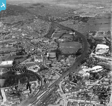
EPW049817 ENGLAND (1936). The London, Midland & Scottish Railway (LMSR) Bushey Curve, the High Street and environs, Watford, from the south-east, 1936
    © Copyright OpenStreetMap contributors and licensed by the OpenStreetMap Foundation. 2025. Cartography is licensed as CC BY-SA.
  
Nearby Images (10)
Details
| Title | [EPW049817] The London, Midland & Scottish Railway (LMSR) Bushey Curve, the High Street and environs, Watford, from the south-east, 1936 | 
| Reference | EPW049817 | 
| Date | May-1936 | 
| Link | |
| Place name | WATFORD | 
| Parish | |
| District | |
| Country | ENGLAND | 
| Easting / Northing | 511803, 195580 | 
| Longitude / Latitude | -0.38387847695386, 51.647419583935 | 
| National Grid Reference | TQ118956 | 
Pins
|  St Matthews Church |   Owen | Thursday 13th of February 2020 07:09:12 PM | 
|  North Watford and Garston. |   OldBill | Monday 18th of June 2018 08:51:42 PM | 
|  Radlett Road |   OldBill | Monday 18th of June 2018 08:48:42 PM | 
|  The real Water Lane. The other one indicated on this map is incorrect. |   OldBill | Monday 18th of June 2018 08:43:03 PM | 
|  The London Orphan Asylum. Now a load of posh expensive commuter flats. |   OldBill | Saturday 16th of December 2017 08:39:12 PM | 
|  The death trap! nasty corner - in the 30s 40s - from Radlett Road. |   OldBill | Saturday 16th of December 2017 08:37:01 PM | 
|  Pinner Road (via Oxhey Lane). |   OldBill | Saturday 16th of December 2017 08:34:27 PM | 
|  The Victoria |   OldBill | Saturday 16th of December 2017 08:32:41 PM | 
|  The Railway Arms |   OldBill | Saturday 16th of December 2017 08:29:53 PM | 
|  Aldenham Road |   OldBill | Saturday 16th of December 2017 08:27:16 PM | 
|  Bushey and Oxhey local line platform, to Watford High St etc |   OldBill | Saturday 16th of December 2017 08:26:07 PM | 
|  Bushey and Oxhey station mainline platforms |   OldBill | Saturday 16th of December 2017 08:24:58 PM | 
|  Water Lane |   OldBill | Saturday 16th of December 2017 08:22:44 PM | 
|  The Cricketers, Watford Fields |   OldBill | Wednesday 1st of November 2017 07:59:29 PM | 
|  Benskins brewery |   OldBill | Wednesday 1st of November 2017 07:58:29 PM | 
|  Site of B and Q |   Brad | Saturday 8th of October 2016 09:36:22 AM | 
|  Hit and Miss Pub |   Brad | Saturday 8th of October 2016 09:35:41 AM | 
|  Geo Ausden Ltd |   Brad | Saturday 8th of October 2016 09:35:09 AM | 
|  Fractionally to the right - Junction Chalk Hill / Villiers Road Postcard Postally used 1965 |   ordinarybloke | Monday 10th of March 2014 12:51:43 AM | 
|  Frogmore House |   Lost Heart | Wednesday 29th of May 2013 05:51:03 PM | 
|  Oxhey Infants School |   ordinarybloke | Tuesday 7th of May 2013 09:36:23 AM | 
User Comment Contributions
|   ordinarybloke | Tuesday 7th of May 2013 09:37:21 AM | 
 
             
  ![[EPW049817] The London, Midland & Scottish Railway (LMSR) Bushey Curve, the High Street and environs, Watford, from the south-east, 1936](http://britainfromabove.org.uk/sites/all/libraries/aerofilms-images/public/100x100/EPW/049/EPW049817.jpg) 
  
                                          ![[EPW049814] The London, Midland & Scottish Railway (LMSR) Bushey Curve, the High Street and environs, Watford, from the south-west, 1936](http://britainfromabove.org.uk/sites/all/libraries/aerofilms-images/public/100x100/EPW/049/EPW049814.jpg) 
 ![[EPW049825] Gas Works adjacent to the London, Midland & Scottish Railway (LMSR) Bushey Curve and environs, Watford, 1936](http://britainfromabove.org.uk/sites/all/libraries/aerofilms-images/public/100x100/EPW/049/EPW049825.jpg) 
 ![[EPW049818] The London, Midland & Scottish Railway (LMSR) Bushey Curve, the High Street and environs, Watford, from the south-west, 1936](http://britainfromabove.org.uk/sites/all/libraries/aerofilms-images/public/100x100/EPW/049/EPW049818.jpg) 
 ![[EPW049823] The London, Midland & Scottish Railway (LMSR) Bushey Curve, the High Street and environs, Watford, 1936](http://britainfromabove.org.uk/sites/all/libraries/aerofilms-images/public/100x100/EPW/049/EPW049823.jpg) 
 ![[EPW049816] The Colne Valley Water Company Plc Water Works, Watford High Street and environs, Bushey, from the east, 1936](http://britainfromabove.org.uk/sites/all/libraries/aerofilms-images/public/100x100/EPW/049/EPW049816.jpg) 
 ![[EPW060227] The London, Midland and Scottish Railway Line near Bushey Hall and environs, Watford, from the south-east, 1938](http://britainfromabove.org.uk/sites/all/libraries/aerofilms-images/public/100x100/EPW/060/EPW060227.jpg) 
 ![[EPW049813] The LMSR Bushey Curve, the High Street and environs, Watford, 1936](http://britainfromabove.org.uk/sites/all/libraries/aerofilms-images/public/100x100/EPW/049/EPW049813.jpg) 
 ![[EPW049819] The Colne Valley Water Company Plc Water Works and environs, Bushey, 1936](http://britainfromabove.org.uk/sites/all/libraries/aerofilms-images/public/100x100/EPW/049/EPW049819.jpg) 
 ![[EPW021879] Bushey and surroundings, Bushey, from the north-east, 1928](http://britainfromabove.org.uk/sites/all/libraries/aerofilms-images/public/100x100/EPW/021/EPW021879.jpg) 
 
