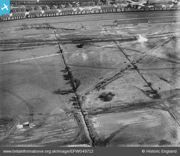
EPW049712 ENGLAND (1936). The site of the southern end of the William Girling Reservoir showing preliminary construction works, Edmonton, 1936
© Copyright OpenStreetMap contributors and licensed by the OpenStreetMap Foundation. 2026. Cartography is licensed as CC BY-SA.
Nearby Images (33)
Details
| Title | [EPW049712] The site of the southern end of the William Girling Reservoir showing preliminary construction works, Edmonton, 1936 |
| Reference | EPW049712 |
| Date | March-1936 |
| Link | |
| Place name | EDMONTON |
| Parish | |
| District | |
| Country | ENGLAND |
| Easting / Northing | 536384, 193162 |
| Longitude / Latitude | -0.029706272216836, 51.62026359693 |
| National Grid Reference | TQ364932 |
Pins
Be the first to add a comment to this image!


![[EPW049712] The site of the southern end of the William Girling Reservoir showing preliminary construction works, Edmonton, 1936](http://britainfromabove.org.uk/sites/all/libraries/aerofilms-images/public/100x100/EPW/049/EPW049712.jpg)
![[EPW056325] The southern end of the William Girling Reservoir under construction, Edmonton, 1938](http://britainfromabove.org.uk/sites/all/libraries/aerofilms-images/public/100x100/EPW/056/EPW056325.jpg)
![[EPW056316] The William Girling Reservoir under construction, Edmonton, from the south, 1938](http://britainfromabove.org.uk/sites/all/libraries/aerofilms-images/public/100x100/EPW/056/EPW056316.jpg)
![[EPW053855] The southern part of the Chingford (William Girling) Reservoir under construction, Edmonton, 1937](http://britainfromabove.org.uk/sites/all/libraries/aerofilms-images/public/100x100/EPW/053/EPW053855.jpg)
![[EPW055987] The William Girling Reservoir under construction, Lower Edmonton, 1937](http://britainfromabove.org.uk/sites/all/libraries/aerofilms-images/public/100x100/EPW/055/EPW055987.jpg)
![[EPW056825] The southern end of the William Girling Reservoir under construction, Edmonton, 1938](http://britainfromabove.org.uk/sites/all/libraries/aerofilms-images/public/100x100/EPW/056/EPW056825.jpg)
![[EPW058468] The southern part of the Chingford (William Girling) Reservoir under construction, Edmonton, 1938](http://britainfromabove.org.uk/sites/all/libraries/aerofilms-images/public/100x100/EPW/058/EPW058468.jpg)
![[EPW053841] The southern part of the Chingford (William Girling) Reservoir under construction, Edmonton, 1937](http://britainfromabove.org.uk/sites/all/libraries/aerofilms-images/public/100x100/EPW/053/EPW053841.jpg)
![[EPW056814] The William Girling Reservoir under construction, Edmonton, 1938](http://britainfromabove.org.uk/sites/all/libraries/aerofilms-images/public/100x100/EPW/056/EPW056814.jpg)
![[EPW060634] The William Girling Reservoir under construction, Lower Edmonton, 1939](http://britainfromabove.org.uk/sites/all/libraries/aerofilms-images/public/100x100/EPW/060/EPW060634.jpg)
![[EPW060627] The William Girling Reservoir under construction, Lower Edmonton, 1939](http://britainfromabove.org.uk/sites/all/libraries/aerofilms-images/public/100x100/EPW/060/EPW060627.jpg)
![[EPW050869] The site of the William Girling Reservoir showing preliminary construction works, Edmonton, 1936](http://britainfromabove.org.uk/sites/all/libraries/aerofilms-images/public/100x100/EPW/050/EPW050869.jpg)
![[EPW053840] The southern part of the Chingford (William Girling) Reservoir under construction, Edmonton, 1937](http://britainfromabove.org.uk/sites/all/libraries/aerofilms-images/public/100x100/EPW/053/EPW053840.jpg)
![[EPW058460] The southern part of the Chingford (William Girling) Reservoir under construction, Edmonton, 1938](http://britainfromabove.org.uk/sites/all/libraries/aerofilms-images/public/100x100/EPW/058/EPW058460.jpg)
![[EPW053838] The southern part of the Chingford (William Girling) Reservoir under construction, Edmonton, 1937](http://britainfromabove.org.uk/sites/all/libraries/aerofilms-images/public/100x100/EPW/053/EPW053838.jpg)
![[EPW055982] The William Girling Reservoir under construction, Lower Edmonton, 1937](http://britainfromabove.org.uk/sites/all/libraries/aerofilms-images/public/100x100/EPW/055/EPW055982.jpg)
![[EPW049714] The site of the southern end of the William Girling Reservoir showing preliminary construction works, Edmonton, 1936](http://britainfromabove.org.uk/sites/all/libraries/aerofilms-images/public/100x100/EPW/049/EPW049714.jpg)
![[EPW052273] The site of the southern end of the William Girling Reservoir showing preliminary construction works, Edmonton, 1936](http://britainfromabove.org.uk/sites/all/libraries/aerofilms-images/public/100x100/EPW/052/EPW052273.jpg)
![[EPW060209] The southern part of the Chingford (William Girling) Reservoir under construction, Edmonton, 1938](http://britainfromabove.org.uk/sites/all/libraries/aerofilms-images/public/100x100/EPW/060/EPW060209.jpg)
![[EPW050862] The site of the William Girling Reservoir showing preliminary construction works, Edmonton, 1936](http://britainfromabove.org.uk/sites/all/libraries/aerofilms-images/public/100x100/EPW/050/EPW050862.jpg)
![[EPW060223] The Chingford (William Girling) Reservoir under construction, Edmonton, from the south, 1938](http://britainfromabove.org.uk/sites/all/libraries/aerofilms-images/public/100x100/EPW/060/EPW060223.jpg)
![[EPW050863] The site of the William Girling Reservoir showing preliminary construction works, Edmonton, 1936](http://britainfromabove.org.uk/sites/all/libraries/aerofilms-images/public/100x100/EPW/050/EPW050863.jpg)
![[EPW055983] The William Girling Reservoir under construction, Lower Edmonton, 1937](http://britainfromabove.org.uk/sites/all/libraries/aerofilms-images/public/100x100/EPW/055/EPW055983.jpg)
![[EPW056817] The southern end of the William Girling Reservoir under construction, Edmonton, 1938](http://britainfromabove.org.uk/sites/all/libraries/aerofilms-images/public/100x100/EPW/056/EPW056817.jpg)
![[EPW056822] The southern end of the William Girling Reservoir under construction, Edmonton, 1938](http://britainfromabove.org.uk/sites/all/libraries/aerofilms-images/public/100x100/EPW/056/EPW056822.jpg)
![[EPW049702] Edmonton Urban District Council Sewage Farm and the site of the southern end of the William Girling Reservoir showing preliminary construction works, Edmonton, 1936](http://britainfromabove.org.uk/sites/all/libraries/aerofilms-images/public/100x100/EPW/049/EPW049702.jpg)
![[EPW056317] The William Girling Reservoir under construction, Edmonton, from the south, 1938](http://britainfromabove.org.uk/sites/all/libraries/aerofilms-images/public/100x100/EPW/056/EPW056317.jpg)
![[EPW056327] The William Girling Reservoir under construction, Edmonton, 1938](http://britainfromabove.org.uk/sites/all/libraries/aerofilms-images/public/100x100/EPW/056/EPW056327.jpg)
![[EPW052281] The site of the William Girling Reservoir showing preliminary construction works, Edmonton, 1936. This image has been produced from a damaged negative.](http://britainfromabove.org.uk/sites/all/libraries/aerofilms-images/public/100x100/EPW/052/EPW052281.jpg)
![[EPW060629] The William Girling Reservoir under construction, Edmonton, 1939. This image has been produced from a damaged negative.](http://britainfromabove.org.uk/sites/all/libraries/aerofilms-images/public/100x100/EPW/060/EPW060629.jpg)
![[EPW058471] The Chingford (William Girling) Reservoir under construction, Edmonton, from the south, 1938](http://britainfromabove.org.uk/sites/all/libraries/aerofilms-images/public/100x100/EPW/058/EPW058471.jpg)
![[EPW056326] The southern end of the William Girling Reservoir under construction, Edmonton, 1938](http://britainfromabove.org.uk/sites/all/libraries/aerofilms-images/public/100x100/EPW/056/EPW056326.jpg)
![[EPW049528] The site of the William Girling Reservoir and Edmonton U.D. Council Sewage Farm, Edmonton, 1935](http://britainfromabove.org.uk/sites/all/libraries/aerofilms-images/public/100x100/EPW/049/EPW049528.jpg)