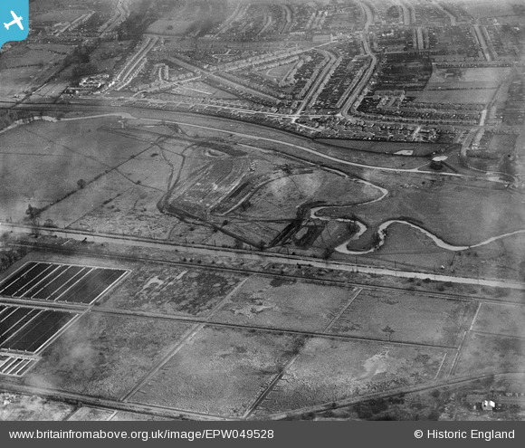
EPW049528 ENGLAND (1935). The site of the William Girling Reservoir and Edmonton U.D. Council Sewage Farm, Edmonton, 1935
© Copyright OpenStreetMap contributors and licensed by the OpenStreetMap Foundation. 2026. Cartography is licensed as CC BY-SA.
Nearby Images (26)
Details
| Title | [EPW049528] The site of the William Girling Reservoir and Edmonton U.D. Council Sewage Farm, Edmonton, 1935 |
| Reference | EPW049528 |
| Date | December-1935 |
| Link | |
| Place name | EDMONTON |
| Parish | |
| District | |
| Country | ENGLAND |
| Easting / Northing | 536136, 192935 |
| Longitude / Latitude | -0.033374986207743, 51.618283593965 |
| National Grid Reference | TQ361929 |
Pins
Be the first to add a comment to this image!


![[EPW049528] The site of the William Girling Reservoir and Edmonton U.D. Council Sewage Farm, Edmonton, 1935](http://britainfromabove.org.uk/sites/all/libraries/aerofilms-images/public/100x100/EPW/049/EPW049528.jpg)
![[EPW056326] The southern end of the William Girling Reservoir under construction, Edmonton, 1938](http://britainfromabove.org.uk/sites/all/libraries/aerofilms-images/public/100x100/EPW/056/EPW056326.jpg)
![[EPW058471] The Chingford (William Girling) Reservoir under construction, Edmonton, from the south, 1938](http://britainfromabove.org.uk/sites/all/libraries/aerofilms-images/public/100x100/EPW/058/EPW058471.jpg)
![[EPW058465] The southern part of the Chingford (William Girling) Reservoir under construction, Edmonton, 1938](http://britainfromabove.org.uk/sites/all/libraries/aerofilms-images/public/100x100/EPW/058/EPW058465.jpg)
![[EPW049715] The site of the southern end of the William Girling Reservoir showing preliminary construction works, Edmonton, 1936](http://britainfromabove.org.uk/sites/all/libraries/aerofilms-images/public/100x100/EPW/049/EPW049715.jpg)
![[EPW058461] The southern end of the Chingford (William Girling) Reservoir under construction and the River Lea, Edmonton, 1938](http://britainfromabove.org.uk/sites/all/libraries/aerofilms-images/public/100x100/EPW/058/EPW058461.jpg)
![[EPW049702] Edmonton Urban District Council Sewage Farm and the site of the southern end of the William Girling Reservoir showing preliminary construction works, Edmonton, 1936](http://britainfromabove.org.uk/sites/all/libraries/aerofilms-images/public/100x100/EPW/049/EPW049702.jpg)
![[EPW049722] Edmonton Urban District Council Sewage Farm and the site of the southern end of the William Girling Reservoir showing preliminary construction works, Edmonton, 1936](http://britainfromabove.org.uk/sites/all/libraries/aerofilms-images/public/100x100/EPW/049/EPW049722.jpg)
![[EPW060629] The William Girling Reservoir under construction, Edmonton, 1939. This image has been produced from a damaged negative.](http://britainfromabove.org.uk/sites/all/libraries/aerofilms-images/public/100x100/EPW/060/EPW060629.jpg)
![[EPW056817] The southern end of the William Girling Reservoir under construction, Edmonton, 1938](http://britainfromabove.org.uk/sites/all/libraries/aerofilms-images/public/100x100/EPW/056/EPW056817.jpg)
![[EPW055982] The William Girling Reservoir under construction, Lower Edmonton, 1937](http://britainfromabove.org.uk/sites/all/libraries/aerofilms-images/public/100x100/EPW/055/EPW055982.jpg)
![[EPW052273] The site of the southern end of the William Girling Reservoir showing preliminary construction works, Edmonton, 1936](http://britainfromabove.org.uk/sites/all/libraries/aerofilms-images/public/100x100/EPW/052/EPW052273.jpg)
![[EPW049727] Edmonton Urban District Council Sewage Farm and the site of the southern end of the William Girling Reservoir showing preliminary construction works, Edmonton, 1936](http://britainfromabove.org.uk/sites/all/libraries/aerofilms-images/public/100x100/EPW/049/EPW049727.jpg)
![[EPW050869] The site of the William Girling Reservoir showing preliminary construction works, Edmonton, 1936](http://britainfromabove.org.uk/sites/all/libraries/aerofilms-images/public/100x100/EPW/050/EPW050869.jpg)
![[EPW053843] The River Lea and the southern part of the Chingford (William Girling) Reservoir under construction, Edmonton, 1937](http://britainfromabove.org.uk/sites/all/libraries/aerofilms-images/public/100x100/EPW/053/EPW053843.jpg)
![[EPW053840] The southern part of the Chingford (William Girling) Reservoir under construction, Edmonton, 1937](http://britainfromabove.org.uk/sites/all/libraries/aerofilms-images/public/100x100/EPW/053/EPW053840.jpg)
![[EPW056319] The River Lea at the southern end of the site of the William Girling Reservoir, Edmonton, 1938](http://britainfromabove.org.uk/sites/all/libraries/aerofilms-images/public/100x100/EPW/056/EPW056319.jpg)
![[EPW049714] The site of the southern end of the William Girling Reservoir showing preliminary construction works, Edmonton, 1936](http://britainfromabove.org.uk/sites/all/libraries/aerofilms-images/public/100x100/EPW/049/EPW049714.jpg)
![[EPW056822] The southern end of the William Girling Reservoir under construction, Edmonton, 1938](http://britainfromabove.org.uk/sites/all/libraries/aerofilms-images/public/100x100/EPW/056/EPW056822.jpg)
![[EPW049523] Edmonton U.D. Council Sewage Farm, the Wireless Works and environs, Edmonton, 1935](http://britainfromabove.org.uk/sites/all/libraries/aerofilms-images/public/100x100/EPW/049/EPW049523.jpg)
![[EPW056815] The William Girling Reservoir under construction, Edmonton, 1938](http://britainfromabove.org.uk/sites/all/libraries/aerofilms-images/public/100x100/EPW/056/EPW056815.jpg)
![[EPW053841] The southern part of the Chingford (William Girling) Reservoir under construction, Edmonton, 1937](http://britainfromabove.org.uk/sites/all/libraries/aerofilms-images/public/100x100/EPW/053/EPW053841.jpg)
![[EPW049696] The area to the southern end of the William Girling Reservoir showing preliminary construction works, Edmonton, 1936](http://britainfromabove.org.uk/sites/all/libraries/aerofilms-images/public/100x100/EPW/049/EPW049696.jpg)
![[EPW052274] The site of the southern end of the William Girling Reservoir showing preliminary construction works, Edmonton, 1936. This image has been produced from a damaged negative.](http://britainfromabove.org.uk/sites/all/libraries/aerofilms-images/public/100x100/EPW/052/EPW052274.jpg)
![[EPW056325] The southern end of the William Girling Reservoir under construction, Edmonton, 1938](http://britainfromabove.org.uk/sites/all/libraries/aerofilms-images/public/100x100/EPW/056/EPW056325.jpg)
![[EPW049712] The site of the southern end of the William Girling Reservoir showing preliminary construction works, Edmonton, 1936](http://britainfromabove.org.uk/sites/all/libraries/aerofilms-images/public/100x100/EPW/049/EPW049712.jpg)