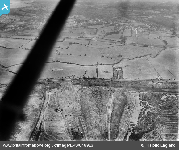
EPW048913 ENGLAND (1935). Gravel Pits alongside the site of the William Girling Reservoir, Lower Edmonton, 1935
© Copyright OpenStreetMap contributors and licensed by the OpenStreetMap Foundation. 2026. Cartography is licensed as CC BY-SA.
Nearby Images (18)
Details
| Title | [EPW048913] Gravel Pits alongside the site of the William Girling Reservoir, Lower Edmonton, 1935 |
| Reference | EPW048913 |
| Date | August-1935 |
| Link | |
| Place name | LOWER EDMONTON |
| Parish | |
| District | |
| Country | ENGLAND |
| Easting / Northing | 536543, 194306 |
| Longitude / Latitude | -0.026964652216252, 51.630506143373 |
| National Grid Reference | TQ365943 |
Pins
Be the first to add a comment to this image!


![[EPW048913] Gravel Pits alongside the site of the William Girling Reservoir, Lower Edmonton, 1935](http://britainfromabove.org.uk/sites/all/libraries/aerofilms-images/public/100x100/EPW/048/EPW048913.jpg)
![[EAW040971] The William Girling Reservoir, Enfield, 1951](http://britainfromabove.org.uk/sites/all/libraries/aerofilms-images/public/100x100/EAW/040/EAW040971.jpg)
![[EPW049527] The River Lea Navigation and adjoining gravel pit near Pickett's Lock Lane, Enfield, 1935](http://britainfromabove.org.uk/sites/all/libraries/aerofilms-images/public/100x100/EPW/049/EPW049527.jpg)
![[EPW056334] The William Girling Reservoir under construction, Edmonton, 1938](http://britainfromabove.org.uk/sites/all/libraries/aerofilms-images/public/100x100/EPW/056/EPW056334.jpg)
![[EPW056332] The William Girling Reservoir under construction, Edmonton, 1938](http://britainfromabove.org.uk/sites/all/libraries/aerofilms-images/public/100x100/EPW/056/EPW056332.jpg)
![[EPW050858] The site of the William Girling Reservoir, Edmonton, 1936](http://britainfromabove.org.uk/sites/all/libraries/aerofilms-images/public/100x100/EPW/050/EPW050858.jpg)
![[EAW040970] The William Girling Reservoir, Enfield, 1951](http://britainfromabove.org.uk/sites/all/libraries/aerofilms-images/public/100x100/EAW/040/EAW040970.jpg)
![[EPW058470] The Chingford (William Girling) Reservoir under construction, Edmonton, 1938](http://britainfromabove.org.uk/sites/all/libraries/aerofilms-images/public/100x100/EPW/058/EPW058470.jpg)
![[EPW055976] The northern section of the William Girling Reservoir under construction, Enfield, 1937](http://britainfromabove.org.uk/sites/all/libraries/aerofilms-images/public/100x100/EPW/055/EPW055976.jpg)
![[EPW056820] The William Girling Reservoir under construction, Edmonton, 1938](http://britainfromabove.org.uk/sites/all/libraries/aerofilms-images/public/100x100/EPW/056/EPW056820.jpg)
![[EPW056813] The William Girling Reservoir under construction, Edmonton, 1938](http://britainfromabove.org.uk/sites/all/libraries/aerofilms-images/public/100x100/EPW/056/EPW056813.jpg)
![[EPW050864] The site of the William Girling Reservoir, Edmonton, 1936](http://britainfromabove.org.uk/sites/all/libraries/aerofilms-images/public/100x100/EPW/050/EPW050864.jpg)
![[EPW060631] The William Girling Reservoir under construction, Enfield, 1939](http://britainfromabove.org.uk/sites/all/libraries/aerofilms-images/public/100x100/EPW/060/EPW060631.jpg)
![[EPW052280] The site of the William Girling Reservoir showing preliminary construction works, Edmonton, 1936. This image has been produced from a damaged negative.](http://britainfromabove.org.uk/sites/all/libraries/aerofilms-images/public/100x100/EPW/052/EPW052280.jpg)
![[EPW049700] Aggregates extraction to the north of the Edmonton Urban District Council Sewage Farm, Edmonton, 1936](http://britainfromabove.org.uk/sites/all/libraries/aerofilms-images/public/100x100/EPW/049/EPW049700.jpg)
![[EPW053851] The Chingford (William Girling) Reservoir under construction, Edmonton, 1937](http://britainfromabove.org.uk/sites/all/libraries/aerofilms-images/public/100x100/EPW/053/EPW053851.jpg)
![[EPW056829] The William Girling Reservoir under construction, Edmonton, 1938](http://britainfromabove.org.uk/sites/all/libraries/aerofilms-images/public/100x100/EPW/056/EPW056829.jpg)
![[EPW058464] The northern part of the Chingford (William Girling) Reservoir under construction, Edmonton, 1938](http://britainfromabove.org.uk/sites/all/libraries/aerofilms-images/public/100x100/EPW/058/EPW058464.jpg)