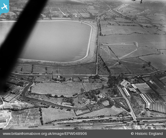
EPW048906 ENGLAND (1935). The G. R. Wright Flour Mill, the southern end of King George's Reservoir and Lea Valley Road, Ponders End, 1935
© Copyright OpenStreetMap contributors and licensed by the OpenStreetMap Foundation. 2026. Cartography is licensed as CC BY-SA.
Details
| Title | [EPW048906] The G. R. Wright Flour Mill, the southern end of King George's Reservoir and Lea Valley Road, Ponders End, 1935 |
| Reference | EPW048906 |
| Date | August-1935 |
| Link | |
| Place name | PONDERS END |
| Parish | |
| District | |
| Country | ENGLAND |
| Easting / Northing | 536549, 195506 |
| Longitude / Latitude | -0.026409801506555, 51.641289039155 |
| National Grid Reference | TQ365955 |
Pins

G.Martin |
Monday 16th of June 2014 12:27:17 PM | |

Ray Flack |
Thursday 20th of February 2014 01:35:02 PM | |

Ray Flack |
Thursday 20th of February 2014 01:33:07 PM | |

Ray Flack |
Thursday 20th of February 2014 01:31:58 PM | |

Ray Flack |
Thursday 20th of February 2014 01:30:47 PM | |

Ray Flack |
Thursday 20th of February 2014 01:30:06 PM | |

Ray Flack |
Thursday 20th of February 2014 01:29:27 PM | |

Ray Flack |
Thursday 20th of February 2014 01:28:41 PM | |

Ray Flack |
Thursday 20th of February 2014 01:28:00 PM | |

Ray Flack |
Thursday 20th of February 2014 01:27:10 PM | |

Ray Flack |
Thursday 20th of February 2014 01:26:01 PM | |

Ray Flack |
Thursday 20th of February 2014 01:23:47 PM | |

Ray Flack |
Thursday 20th of February 2014 01:21:45 PM | |

Ray Flack |
Thursday 20th of February 2014 01:20:34 PM | |

Ray Flack |
Thursday 20th of February 2014 01:19:26 PM | |

Ray Flack |
Thursday 20th of February 2014 01:17:16 PM | |

JackieB |
Wednesday 20th of November 2013 05:07:54 PM | |

JackieB |
Wednesday 20th of November 2013 05:07:00 PM |


![[EPW048906] The G. R. Wright Flour Mill, the southern end of King George's Reservoir and Lea Valley Road, Ponders End, 1935](http://britainfromabove.org.uk/sites/all/libraries/aerofilms-images/public/100x100/EPW/048/EPW048906.jpg)
![[EPW048904] The southern end of King George's Reservoir, the Charlotte Cabinet Works and Lea Valley Road, Ponders End, 1935](http://britainfromabove.org.uk/sites/all/libraries/aerofilms-images/public/100x100/EPW/048/EPW048904.jpg)
![[EPW049704] The site of the northern end of the William Girling Reservoir showing preliminary construction works, Ponders End, 1936](http://britainfromabove.org.uk/sites/all/libraries/aerofilms-images/public/100x100/EPW/049/EPW049704.jpg)