
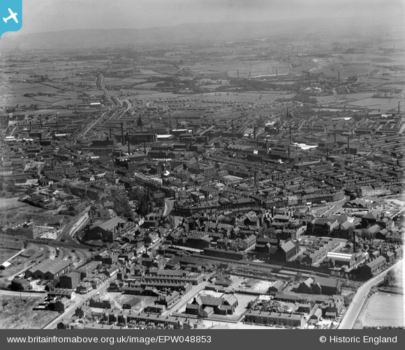
EPW048853 ENGLAND (1935). The town, Bury, from the west, 1935
© Copyright OpenStreetMap contributors and licensed by the OpenStreetMap Foundation. 2026. Cartography is licensed as CC BY-SA.
Nearby Images (6)
EPW048853

EPW018496

EPW018500

EAW015989

EAW015986

EAW015987

Details
| Title | [EPW048853] The town, Bury, from the west, 1935 |
| Reference | EPW048853 |
| Date | August-1935 |
| Link | |
| Place name | BURY |
| Parish | |
| District | |
| Country | ENGLAND |
| Easting / Northing | 380393, 410770 |
| Longitude / Latitude | -2.2962635044747, 53.592901002195 |
| National Grid Reference | SD804108 |
Pins

muso2001 |
Sunday 1st of October 2017 11:54:57 AM | |
|
muso2001 |
Sunday 1st of October 2017 11:54:20 AM | |
|
muso2001 |
Sunday 1st of October 2017 11:53:06 AM | |
|
muso2001 |
Sunday 1st of October 2017 11:51:00 AM | |
|
muso2001 |
Sunday 1st of October 2017 11:40:19 AM | |
|
John Wass |
Saturday 13th of September 2014 08:56:40 PM | |
|
H.J.Hill |
Wednesday 21st of May 2014 12:05:50 AM | |
|
Smallbrainfield |
Tuesday 21st of January 2014 11:57:37 AM | |
|
totoro |
Wednesday 8th of May 2013 09:39:29 PM | |
|
totoro |
Wednesday 8th of May 2013 09:38:38 PM | |
|
totoro |
Wednesday 8th of May 2013 09:35:54 PM | |
|
totoro |
Wednesday 8th of May 2013 09:34:51 PM |