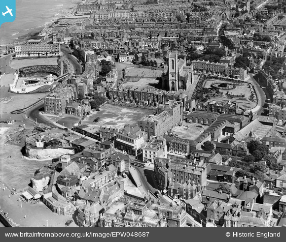
EPW048687 ENGLAND (1935). The Cobb and Co Brewery below Trinity Church and environs, Margate, 1935
© Copyright OpenStreetMap contributors and licensed by the OpenStreetMap Foundation. 2026. Cartography is licensed as CC BY-SA.
Nearby Images (26)
Details
| Title | [EPW048687] The Cobb and Co Brewery below Trinity Church and environs, Margate, 1935 |
| Reference | EPW048687 |
| Date | July-1935 |
| Link | |
| Place name | MARGATE |
| Parish | |
| District | |
| Country | ENGLAND |
| Easting / Northing | 635551, 171214 |
| Longitude / Latitude | 1.3861369244793, 51.390494078745 |
| National Grid Reference | TR356712 |
Pins
Be the first to add a comment to this image!


![[EPW048687] The Cobb and Co Brewery below Trinity Church and environs, Margate, 1935](http://britainfromabove.org.uk/sites/all/libraries/aerofilms-images/public/100x100/EPW/048/EPW048687.jpg)
![[EPW048686] The Cobb and Co Brewery below Trinity Church and environs, Margate, 1935](http://britainfromabove.org.uk/sites/all/libraries/aerofilms-images/public/100x100/EPW/048/EPW048686.jpg)
![[EPW048685] The Cobb and Co Brewery below Trinity Church and environs, Margate, 1935](http://britainfromabove.org.uk/sites/all/libraries/aerofilms-images/public/100x100/EPW/048/EPW048685.jpg)
![[EPW048688] The Cobb and Co Brewery below Trinity Church and environs, Margate, 1935](http://britainfromabove.org.uk/sites/all/libraries/aerofilms-images/public/100x100/EPW/048/EPW048688.jpg)
![[EPW048690] The Cobb and Co Brewery and environs, Margate, 1935](http://britainfromabove.org.uk/sites/all/libraries/aerofilms-images/public/100x100/EPW/048/EPW048690.jpg)
![[EPW048689] The Cobb and Co Brewery and environs, Margate, 1935](http://britainfromabove.org.uk/sites/all/libraries/aerofilms-images/public/100x100/EPW/048/EPW048689.jpg)
![[EPW048692] The Cobb and Co Brewery below Trinity Church and environs, Margate, 1935](http://britainfromabove.org.uk/sites/all/libraries/aerofilms-images/public/100x100/EPW/048/EPW048692.jpg)
![[EPW048684] The Cobb and Co Brewery below Trinity Church and environs, Margate, 1935](http://britainfromabove.org.uk/sites/all/libraries/aerofilms-images/public/100x100/EPW/048/EPW048684.jpg)
![[EPW000624] Trinity Church, Margate, 1920](http://britainfromabove.org.uk/sites/all/libraries/aerofilms-images/public/100x100/EPW/000/EPW000624.jpg)
![[EPW048691] The Cobb and Co Brewery below Trinity Church and environs, Margate, 1935. This image has been produced from a damaged negative.](http://britainfromabove.org.uk/sites/all/libraries/aerofilms-images/public/100x100/EPW/048/EPW048691.jpg)
![[EPW000636] Trinity Church, Margate, 1920](http://britainfromabove.org.uk/sites/all/libraries/aerofilms-images/public/100x100/EPW/000/EPW000636.jpg)
![[EPW000633] The Winter Gardens, Margate, from the west, 1920](http://britainfromabove.org.uk/sites/all/libraries/aerofilms-images/public/100x100/EPW/000/EPW000633.jpg)
![[EPW018600] Trinity Church and the town, Margate, 1927. This image has been produced from a print.](http://britainfromabove.org.uk/sites/all/libraries/aerofilms-images/public/100x100/EPW/018/EPW018600.jpg)
![[EPW048846] The harbour, town and seafront, Margate, from the south-west, 1935](http://britainfromabove.org.uk/sites/all/libraries/aerofilms-images/public/100x100/EPW/048/EPW048846.jpg)
![[EPW035470] Trinity Church, Fort Green and the Winter Gardens, Margate, 1931](http://britainfromabove.org.uk/sites/all/libraries/aerofilms-images/public/100x100/EPW/035/EPW035470.jpg)
![[EPW000638] The Winter Gardens and Trinity Church, Margate, 1920](http://britainfromabove.org.uk/sites/all/libraries/aerofilms-images/public/100x100/EPW/000/EPW000638.jpg)
![[EPW018599] The Harbour and Parade, Margate, 1927](http://britainfromabove.org.uk/sites/all/libraries/aerofilms-images/public/100x100/EPW/018/EPW018599.jpg)
![[EPW000625] The Hotel Metropole and The Parade, Margate, 1920. This image has been produced from a print.](http://britainfromabove.org.uk/sites/all/libraries/aerofilms-images/public/100x100/EPW/000/EPW000625.jpg)
![[EPW000631] The Jetty, Margate, from the south-east, 1920](http://britainfromabove.org.uk/sites/all/libraries/aerofilms-images/public/100x100/EPW/000/EPW000631.jpg)
![[EPW048847] Margate Jetty, the harbour, Marine Drive and environs, Margate, 1935](http://britainfromabove.org.uk/sites/all/libraries/aerofilms-images/public/100x100/EPW/048/EPW048847.jpg)
![[EPW042849] The Winter Gardens and the town, Margate, from the north-east, 1933](http://britainfromabove.org.uk/sites/all/libraries/aerofilms-images/public/100x100/EPW/042/EPW042849.jpg)
![[EPW000627] The Harbour, Margate, 1920](http://britainfromabove.org.uk/sites/all/libraries/aerofilms-images/public/100x100/EPW/000/EPW000627.jpg)
![[EPW048845] The harbour and town, Margate, 1935](http://britainfromabove.org.uk/sites/all/libraries/aerofilms-images/public/100x100/EPW/048/EPW048845.jpg)
![[EPW009241] The Parade and environs, Margate, 1923](http://britainfromabove.org.uk/sites/all/libraries/aerofilms-images/public/100x100/EPW/009/EPW009241.jpg)
![[EAW015840] The Winter Gardens, Jetty Extension and harbour, Margate, 1948. This image has been produced from a damaged negative.](http://britainfromabove.org.uk/sites/all/libraries/aerofilms-images/public/100x100/EAW/015/EAW015840.jpg)
![[EPW035467] The Margate Jetty and Pier, Margate, from the north-east, 1931](http://britainfromabove.org.uk/sites/all/libraries/aerofilms-images/public/100x100/EPW/035/EPW035467.jpg)