
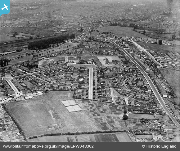
EPW048302 ENGLAND (1935). St Oswald's Church and housing surrounding Tyntesfield Road and Wrington Crescent, Bedminster Down, 1935
© Copyright OpenStreetMap contributors and licensed by the OpenStreetMap Foundation. 2026. Cartography is licensed as CC BY-SA.
Nearby Images (2)
EPW048302

EPW048301

Details
| Title | [EPW048302] St Oswald's Church and housing surrounding Tyntesfield Road and Wrington Crescent, Bedminster Down, 1935 |
| Reference | EPW048302 |
| Date | July-1935 |
| Link | |
| Place name | BEDMINSTER DOWN |
| Parish | |
| District | |
| Country | ENGLAND |
| Easting / Northing | 357167, 169596 |
| Longitude / Latitude | -2.6161046561432, 51.423261464412 |
| National Grid Reference | ST572696 |
Pins

Andrew Lawrence |
Friday 5th of February 2021 12:28:56 AM | |
|
deano8 |
Sunday 8th of January 2017 04:25:43 PM | |
|
deano8 |
Sunday 8th of January 2017 04:25:39 PM | |

Class31 |
Thursday 27th of February 2014 11:53:47 PM | |
|
Class31 |
Thursday 27th of February 2014 11:52:55 PM | |
|
Class31 |
Thursday 27th of February 2014 11:52:31 PM | |
|
Class31 |
Thursday 27th of February 2014 11:51:31 PM | |
|
Class31 |
Thursday 27th of February 2014 11:51:06 PM | |
|
Class31 |
Thursday 27th of February 2014 11:50:44 PM | |
|
MB |
Tuesday 25th of February 2014 10:53:35 PM | |
|
MB |
Tuesday 25th of February 2014 10:51:53 PM | |
|
MB |
Tuesday 25th of February 2014 10:49:14 PM | |
|
MB |
Tuesday 25th of February 2014 10:43:58 PM | |
|
MB |
Tuesday 25th of February 2014 10:42:13 PM |