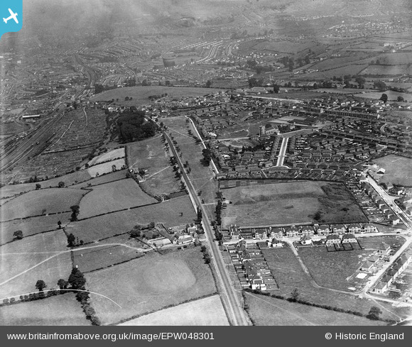
EPW048301 ENGLAND (1935). Elm Farm and housing surrounding Felton Grove, Bedminster Down, 1935
© Copyright OpenStreetMap contributors and licensed by the OpenStreetMap Foundation. 2026. Cartography is licensed as CC BY-SA.
Details
| Title | [EPW048301] Elm Farm and housing surrounding Felton Grove, Bedminster Down, 1935 |
| Reference | EPW048301 |
| Date | July-1935 |
| Link | |
| Place name | BEDMINSTER DOWN |
| Parish | |
| District | |
| Country | ENGLAND |
| Easting / Northing | 356940, 169729 |
| Longitude / Latitude | -2.6193857594033, 51.424440208015 |
| National Grid Reference | ST569697 |
Pins

MB |
Wednesday 26th of February 2014 08:14:34 AM | |

Class31 |
Friday 5th of July 2013 08:30:05 AM | |

Class31 |
Friday 5th of July 2013 08:29:05 AM | |

Class31 |
Friday 5th of July 2013 08:26:15 AM | |

Class31 |
Friday 5th of July 2013 08:25:21 AM | |

Class31 |
Friday 5th of July 2013 08:24:03 AM | |

Class31 |
Friday 5th of July 2013 08:22:22 AM | |

Class31 |
Friday 5th of July 2013 08:20:27 AM | |

Class31 |
Friday 5th of July 2013 08:19:28 AM | |

Class31 |
Friday 5th of July 2013 08:15:48 AM | |

Class31 |
Friday 5th of July 2013 08:15:13 AM | |

Class31 |
Friday 5th of July 2013 08:14:09 AM | |

Class31 |
Friday 5th of July 2013 08:13:16 AM | |

Class31 |
Friday 5th of July 2013 08:11:46 AM | |

Class31 |
Friday 5th of July 2013 08:11:28 AM | |

Class31 |
Friday 5th of July 2013 08:11:07 AM |


![[EPW048301] Elm Farm and housing surrounding Felton Grove, Bedminster Down, 1935](http://britainfromabove.org.uk/sites/all/libraries/aerofilms-images/public/100x100/EPW/048/EPW048301.jpg)
![[EPW048302] St Oswald's Church and housing surrounding Tyntesfield Road and Wrington Crescent, Bedminster Down, 1935](http://britainfromabove.org.uk/sites/all/libraries/aerofilms-images/public/100x100/EPW/048/EPW048302.jpg)