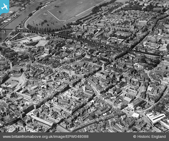
EPW048088 ENGLAND (1935). High Street, the Butts Siding and environs, Worcester, 1935
    © Copyright OpenStreetMap contributors and licensed by the OpenStreetMap Foundation. 2025. Cartography is licensed as CC BY-SA.
  
Nearby Images (13)
Details
| Title | [EPW048088] High Street, the Butts Siding and environs, Worcester, 1935 | 
| Reference | EPW048088 | 
| Date | July-1935 | 
| Link | |
| Place name | WORCESTER | 
| Parish | |
| District | |
| Country | ENGLAND | 
| Easting / Northing | 384915, 255035 | 
| Longitude / Latitude | -2.2207074531428, 52.19294441954 | 
| National Grid Reference | SO849550 | 
Pins
| Class31 | Saturday 21st of May 2016 10:26:45 PM | |
|  Trinity Hall - now demolished and a car park |   Red Baron | Thursday 6th of June 2013 07:42:13 PM | 
|  Worcester Guildhall |   Red Baron | Thursday 6th of June 2013 07:41:13 PM | 
|  Foregate Street Bridge - recently restored in 2013. |   Red Baron | Thursday 6th of June 2013 07:40:50 PM | 
|  Worcester Gaol in Castle Street |   Red Baron | Thursday 6th of June 2013 07:39:19 PM | 
|  St Swithins Church |   Red Baron | Thursday 6th of June 2013 07:37:20 PM | 
 
             
  ![[EPW048088] High Street, the Butts Siding and environs, Worcester, 1935](http://britainfromabove.org.uk/sites/all/libraries/aerofilms-images/public/100x100/EPW/048/EPW048088.jpg) 
  
                                          ![[EPW001298] St Nicholas's Church and The Cross, Worcester, 1920](http://britainfromabove.org.uk/sites/all/libraries/aerofilms-images/public/100x100/EPW/001/EPW001298.jpg) 
 ![[EAW003989] Flooding along the River Severn around Worcester Bridge and the railway viaduct, Worcester, from the south-west, 1947](http://britainfromabove.org.uk/sites/all/libraries/aerofilms-images/public/100x100/EAW/003/EAW003989.jpg) 
 ![[EPW000211] Angel Place, Worcester, 1920](http://britainfromabove.org.uk/sites/all/libraries/aerofilms-images/public/100x100/EPW/000/EPW000211.jpg) 
 ![[EPW001302] Foregate Street and The Cross, Worcester, 1920](http://britainfromabove.org.uk/sites/all/libraries/aerofilms-images/public/100x100/EPW/001/EPW001302.jpg) 
 ![[EPW000399] Worcester, 1920](http://britainfromabove.org.uk/sites/all/libraries/aerofilms-images/public/100x100/EPW/000/EPW000399.jpg) 
 ![[EPW005407] General view of the city, Worcester, 1921](http://britainfromabove.org.uk/sites/all/libraries/aerofilms-images/public/100x100/EPW/005/EPW005407.jpg) 
 ![[EPW000204] All Saints Church and St Andrew's Church, Worcester, 1920](http://britainfromabove.org.uk/sites/all/libraries/aerofilms-images/public/100x100/EPW/000/EPW000204.jpg) 
 ![[EPW005406] General view of the city, Worcester, from the south-west, 1921](http://britainfromabove.org.uk/sites/all/libraries/aerofilms-images/public/100x100/EPW/005/EPW005406.jpg) 
 ![[EPW000206] All Saints Church, Worcester, 1920](http://britainfromabove.org.uk/sites/all/libraries/aerofilms-images/public/100x100/EPW/000/EPW000206.jpg) 
 ![[EPW005384] Bridge Street and environs, Worcester, 1921](http://britainfromabove.org.uk/sites/all/libraries/aerofilms-images/public/100x100/EPW/005/EPW005384.jpg) 
 ![[EAW046113] The town around St Andrew's Spire, Worcester, 1952](http://britainfromabove.org.uk/sites/all/libraries/aerofilms-images/public/100x100/EAW/046/EAW046113.jpg) 
 ![[EPW001300] Worcester Bridge, Worcester, 1920](http://britainfromabove.org.uk/sites/all/libraries/aerofilms-images/public/100x100/EPW/001/EPW001300.jpg)