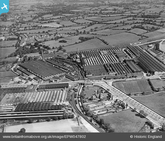
EPW047802 ENGLAND (1935). Longbridge Motor Works, Longbridge, from the north-west, 1935
© Copyright OpenStreetMap contributors and licensed by the OpenStreetMap Foundation. 2026. Cartography is licensed as CC BY-SA.
Nearby Images (21)
Details
| Title | [EPW047802] Longbridge Motor Works, Longbridge, from the north-west, 1935 |
| Reference | EPW047802 |
| Date | June-1935 |
| Link | |
| Place name | LONGBRIDGE |
| Parish | |
| District | |
| Country | ENGLAND |
| Easting / Northing | 400673, 277595 |
| Longitude / Latitude | -1.9901082654967, 52.39599391718 |
| National Grid Reference | SP007776 |
Pins

Graham |
Tuesday 3rd of December 2013 04:14:53 PM |


![[EPW047802] Longbridge Motor Works, Longbridge, from the north-west, 1935](http://britainfromabove.org.uk/sites/all/libraries/aerofilms-images/public/100x100/EPW/047/EPW047802.jpg)
![[EPW047792] Longbridge Motor Works, Longbridge, from the north-west, 1935](http://britainfromabove.org.uk/sites/all/libraries/aerofilms-images/public/100x100/EPW/047/EPW047792.jpg)
![[EPW024834] The Longbridge Motor Works, Longbridge, 1928. This image has been produced from a damaged negative.](http://britainfromabove.org.uk/sites/all/libraries/aerofilms-images/public/100x100/EPW/024/EPW024834.jpg)
![[EPW026898] Longbridge Motor Works, Longbridge, 1929](http://britainfromabove.org.uk/sites/all/libraries/aerofilms-images/public/100x100/EPW/026/EPW026898.jpg)
![[EPW028876] The Longbridge Motor Works, Longbridge, 1929](http://britainfromabove.org.uk/sites/all/libraries/aerofilms-images/public/100x100/EPW/028/EPW028876.jpg)
![[EPW028874] The Longbridge Motor Works, Longbridge, 1929](http://britainfromabove.org.uk/sites/all/libraries/aerofilms-images/public/100x100/EPW/028/EPW028874.jpg)
![[EPW028875] The Longbridge Motor Works, Longbridge, 1929](http://britainfromabove.org.uk/sites/all/libraries/aerofilms-images/public/100x100/EPW/028/EPW028875.jpg)
![[EPW024822] The Longbridge Motor Works, Longbridge, 1928](http://britainfromabove.org.uk/sites/all/libraries/aerofilms-images/public/100x100/EPW/024/EPW024822.jpg)
![[EPW026902] Longbridge Motor Works, Longbridge, 1929](http://britainfromabove.org.uk/sites/all/libraries/aerofilms-images/public/100x100/EPW/026/EPW026902.jpg)
![[EPW024824] The Longbridge Motor Works, Longbridge, 1928](http://britainfromabove.org.uk/sites/all/libraries/aerofilms-images/public/100x100/EPW/024/EPW024824.jpg)
![[EPW047798] Longbridge Motor Works, Longbridge, 1935](http://britainfromabove.org.uk/sites/all/libraries/aerofilms-images/public/100x100/EPW/047/EPW047798.jpg)
![[EPW026896] Longbridge Motor Works, Longbridge, 1929](http://britainfromabove.org.uk/sites/all/libraries/aerofilms-images/public/100x100/EPW/026/EPW026896.jpg)
![[EPW026903] Longbridge Motor Works, Longbridge, 1929](http://britainfromabove.org.uk/sites/all/libraries/aerofilms-images/public/100x100/EPW/026/EPW026903.jpg)
![[EPW024823] The Longbridge Motor Works, Longbridge, 1928](http://britainfromabove.org.uk/sites/all/libraries/aerofilms-images/public/100x100/EPW/024/EPW024823.jpg)
![[EPW047796] Longbridge Motor Works, Longbridge, from the north-west, 1935](http://britainfromabove.org.uk/sites/all/libraries/aerofilms-images/public/100x100/EPW/047/EPW047796.jpg)
![[EPW047793] Longbridge Motor Works, Longbridge, from the north-west, 1935](http://britainfromabove.org.uk/sites/all/libraries/aerofilms-images/public/100x100/EPW/047/EPW047793.jpg)
![[EPW047785] Longbridge Motor Works, Longbridge, from the north-west, 1935](http://britainfromabove.org.uk/sites/all/libraries/aerofilms-images/public/100x100/EPW/047/EPW047785.jpg)
![[EPW047786] Longbridge Motor Works, Longbridge, from the north-west, 1935](http://britainfromabove.org.uk/sites/all/libraries/aerofilms-images/public/100x100/EPW/047/EPW047786.jpg)
![[EPW047795] Longbridge Motor Works, Longbridge, from the north-west, 1935](http://britainfromabove.org.uk/sites/all/libraries/aerofilms-images/public/100x100/EPW/047/EPW047795.jpg)
![[EPW024831] The Longbridge Motor Works, Longbridge, 1928. This image has been produced from a damaged negative.](http://britainfromabove.org.uk/sites/all/libraries/aerofilms-images/public/100x100/EPW/024/EPW024831.jpg)
![[EPW047789] Longbridge Motor Works, Longbridge, from the north-west, 1935](http://britainfromabove.org.uk/sites/all/libraries/aerofilms-images/public/100x100/EPW/047/EPW047789.jpg)