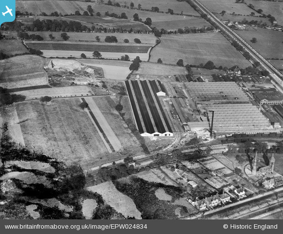
EPW024834 ENGLAND (1928). The Longbridge Motor Works, Longbridge, 1928. This image has been produced from a damaged negative.
© Copyright OpenStreetMap contributors and licensed by the OpenStreetMap Foundation. 2026. Cartography is licensed as CC BY-SA.
Nearby Images (21)
Details
| Title | [EPW024834] The Longbridge Motor Works, Longbridge, 1928. This image has been produced from a damaged negative. |
| Reference | EPW024834 |
| Date | September-1928 |
| Link | |
| Place name | LONGBRIDGE |
| Parish | |
| District | |
| Country | ENGLAND |
| Easting / Northing | 400693, 277724 |
| Longitude / Latitude | -1.9898140390324, 52.397153748587 |
| National Grid Reference | SP007777 |
Pins

ColinA |
Tuesday 17th of July 2012 10:35:26 AM | |

ColinA |
Tuesday 17th of July 2012 10:34:12 AM | |
Actually I believe that this is the old Longbridge pumping station. This is the section of the Bristol Rd where the McDonalds is now. Nazerath House was on the Lickey Rd. |

Eamonmaher |
Tuesday 14th of August 2012 01:06:35 PM |

ypres |
Wednesday 27th of June 2012 09:16:44 AM | |
I believe that this is the old Longbridge pumping station. |

Eamonmaher |
Tuesday 14th of August 2012 01:07:19 PM |

ypres |
Wednesday 27th of June 2012 08:51:23 AM | |

ypres |
Wednesday 27th of June 2012 08:50:44 AM |
User Comment Contributions
The BMC Mini factory? |

Robert - Cumbria |
Wednesday 27th of June 2012 03:32:34 PM |


![[EPW024834] The Longbridge Motor Works, Longbridge, 1928. This image has been produced from a damaged negative.](http://britainfromabove.org.uk/sites/all/libraries/aerofilms-images/public/100x100/EPW/024/EPW024834.jpg)
![[EPW026898] Longbridge Motor Works, Longbridge, 1929](http://britainfromabove.org.uk/sites/all/libraries/aerofilms-images/public/100x100/EPW/026/EPW026898.jpg)
![[EPW028876] The Longbridge Motor Works, Longbridge, 1929](http://britainfromabove.org.uk/sites/all/libraries/aerofilms-images/public/100x100/EPW/028/EPW028876.jpg)
![[EPW028874] The Longbridge Motor Works, Longbridge, 1929](http://britainfromabove.org.uk/sites/all/libraries/aerofilms-images/public/100x100/EPW/028/EPW028874.jpg)
![[EPW028875] The Longbridge Motor Works, Longbridge, 1929](http://britainfromabove.org.uk/sites/all/libraries/aerofilms-images/public/100x100/EPW/028/EPW028875.jpg)
![[EPW024822] The Longbridge Motor Works, Longbridge, 1928](http://britainfromabove.org.uk/sites/all/libraries/aerofilms-images/public/100x100/EPW/024/EPW024822.jpg)
![[EPW026902] Longbridge Motor Works, Longbridge, 1929](http://britainfromabove.org.uk/sites/all/libraries/aerofilms-images/public/100x100/EPW/026/EPW026902.jpg)
![[EPW026896] Longbridge Motor Works, Longbridge, 1929](http://britainfromabove.org.uk/sites/all/libraries/aerofilms-images/public/100x100/EPW/026/EPW026896.jpg)
![[EPW026903] Longbridge Motor Works, Longbridge, 1929](http://britainfromabove.org.uk/sites/all/libraries/aerofilms-images/public/100x100/EPW/026/EPW026903.jpg)
![[EPW024824] The Longbridge Motor Works, Longbridge, 1928](http://britainfromabove.org.uk/sites/all/libraries/aerofilms-images/public/100x100/EPW/024/EPW024824.jpg)
![[EPW024823] The Longbridge Motor Works, Longbridge, 1928](http://britainfromabove.org.uk/sites/all/libraries/aerofilms-images/public/100x100/EPW/024/EPW024823.jpg)
![[EPW047796] Longbridge Motor Works, Longbridge, from the north-west, 1935](http://britainfromabove.org.uk/sites/all/libraries/aerofilms-images/public/100x100/EPW/047/EPW047796.jpg)
![[EPW047792] Longbridge Motor Works, Longbridge, from the north-west, 1935](http://britainfromabove.org.uk/sites/all/libraries/aerofilms-images/public/100x100/EPW/047/EPW047792.jpg)
![[EPW047798] Longbridge Motor Works, Longbridge, 1935](http://britainfromabove.org.uk/sites/all/libraries/aerofilms-images/public/100x100/EPW/047/EPW047798.jpg)
![[EPW047795] Longbridge Motor Works, Longbridge, from the north-west, 1935](http://britainfromabove.org.uk/sites/all/libraries/aerofilms-images/public/100x100/EPW/047/EPW047795.jpg)
![[EPW047786] Longbridge Motor Works, Longbridge, from the north-west, 1935](http://britainfromabove.org.uk/sites/all/libraries/aerofilms-images/public/100x100/EPW/047/EPW047786.jpg)
![[EPW047802] Longbridge Motor Works, Longbridge, from the north-west, 1935](http://britainfromabove.org.uk/sites/all/libraries/aerofilms-images/public/100x100/EPW/047/EPW047802.jpg)
![[EPW024831] The Longbridge Motor Works, Longbridge, 1928. This image has been produced from a damaged negative.](http://britainfromabove.org.uk/sites/all/libraries/aerofilms-images/public/100x100/EPW/024/EPW024831.jpg)
![[EPW047785] Longbridge Motor Works, Longbridge, from the north-west, 1935](http://britainfromabove.org.uk/sites/all/libraries/aerofilms-images/public/100x100/EPW/047/EPW047785.jpg)
![[EPW047789] Longbridge Motor Works, Longbridge, from the north-west, 1935](http://britainfromabove.org.uk/sites/all/libraries/aerofilms-images/public/100x100/EPW/047/EPW047789.jpg)
![[EPW047793] Longbridge Motor Works, Longbridge, from the north-west, 1935](http://britainfromabove.org.uk/sites/all/libraries/aerofilms-images/public/100x100/EPW/047/EPW047793.jpg)