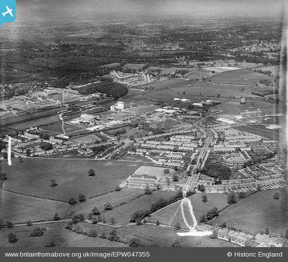
EPW047355 ENGLAND (1935). Peartree and environs, Welwyn Garden City, from the south-east, 1935
© Copyright OpenStreetMap contributors and licensed by the OpenStreetMap Foundation. 2026. Cartography is licensed as CC BY-SA.
Details
| Title | [EPW047355] Peartree and environs, Welwyn Garden City, from the south-east, 1935 |
| Reference | EPW047355 |
| Date | May-1935 |
| Link | |
| Place name | WELWYN GARDEN CITY |
| Parish | |
| District | |
| Country | ENGLAND |
| Easting / Northing | 524592, 212132 |
| Longitude / Latitude | -0.19318453278971, 51.79349535453 |
| National Grid Reference | TL246121 |
Pins

CarolBowes |
Wednesday 27th of December 2023 05:06:13 AM | |

CarolBowes |
Wednesday 27th of December 2023 05:01:38 AM | |

CarolBowes |
Wednesday 27th of December 2023 04:59:23 AM | |

John W |
Wednesday 22nd of March 2017 10:21:01 PM | |

roy-wgc |
Tuesday 1st of November 2016 08:02:27 PM | |

roy-wgc |
Tuesday 1st of November 2016 08:01:43 PM | |

roy-wgc |
Tuesday 1st of November 2016 08:00:49 PM | |

roy-wgc |
Tuesday 1st of November 2016 08:00:04 PM | |

John W |
Thursday 23rd of June 2016 07:49:55 PM |


![[EPW047355] Peartree and environs, Welwyn Garden City, from the south-east, 1935](http://britainfromabove.org.uk/sites/all/libraries/aerofilms-images/public/100x100/EPW/047/EPW047355.jpg)
![[EPW054539] Holwell Primary School, Peartree, 1937](http://britainfromabove.org.uk/sites/all/libraries/aerofilms-images/public/100x100/EPW/054/EPW054539.jpg)
![[EPW062047] A new housing estate at Woodhall under construction, Welwyn Garden City, 1939](http://britainfromabove.org.uk/sites/all/libraries/aerofilms-images/public/100x100/EPW/062/EPW062047.jpg)
![[EAW041978] The Peartree area and environs, Peartree, 1952](http://britainfromabove.org.uk/sites/all/libraries/aerofilms-images/public/100x100/EAW/041/EAW041978.jpg)