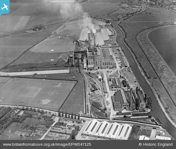
EPW047125 ENGLAND (1935). The Brimsdown Power Station and Water Coolers, Brimsdown, 1935
© Copyright OpenStreetMap contributors and licensed by the OpenStreetMap Foundation. 2026. Cartography is licensed as CC BY-SA.
Nearby Images (31)
Details
| Title | [EPW047125] The Brimsdown Power Station and Water Coolers, Brimsdown, 1935 |
| Reference | EPW047125 |
| Date | May-1935 |
| Link | |
| Place name | BRIMSDOWN |
| Parish | |
| District | |
| Country | ENGLAND |
| Easting / Northing | 536901, 197447 |
| Longitude / Latitude | -0.020565594969711, 51.658647038887 |
| National Grid Reference | TQ369974 |
Pins
Be the first to add a comment to this image!


![[EPW047125] The Brimsdown Power Station and Water Coolers, Brimsdown, 1935](http://britainfromabove.org.uk/sites/all/libraries/aerofilms-images/public/100x100/EPW/047/EPW047125.jpg)
![[EPW047124] The Brimsdown Power Station and Water Coolers alongside King George's Reservoir, Brimsdown, 1935](http://britainfromabove.org.uk/sites/all/libraries/aerofilms-images/public/100x100/EPW/047/EPW047124.jpg)
![[EPW047123] The Brimsdown Power Station and Water Coolers, Brimsdown, 1935](http://britainfromabove.org.uk/sites/all/libraries/aerofilms-images/public/100x100/EPW/047/EPW047123.jpg)
![[EPW021170] Brimsdown Power Station, Brimsdown, 1928. This image has been produced from a copy-negative.](http://britainfromabove.org.uk/sites/all/libraries/aerofilms-images/public/100x100/EPW/021/EPW021170.jpg)
![[EAW000010] Brimsdown Power Station and King George's Reservoir, Brimsdown, 1946](http://britainfromabove.org.uk/sites/all/libraries/aerofilms-images/public/100x100/EAW/000/EAW000010.jpg)
![[EPW047126] The Brimsdown Power Station and Water Coolers, Brimsdown, 1935](http://britainfromabove.org.uk/sites/all/libraries/aerofilms-images/public/100x100/EPW/047/EPW047126.jpg)
![[EPW047128] The Brimsdown Power Station and Water Coolers alongside King George's Reservoir, Brimsdown, 1935](http://britainfromabove.org.uk/sites/all/libraries/aerofilms-images/public/100x100/EPW/047/EPW047128.jpg)
![[EPW047127] The Brimsdown Power Station and Water Coolers, Brimsdown, 1935](http://britainfromabove.org.uk/sites/all/libraries/aerofilms-images/public/100x100/EPW/047/EPW047127.jpg)
![[EPW008047] The Electric Power Station, Enfield, 1922](http://britainfromabove.org.uk/sites/all/libraries/aerofilms-images/public/100x100/EPW/008/EPW008047.jpg)
![[EAW005266] Brimsdown Power Station and environs, Brimsdown, 1947](http://britainfromabove.org.uk/sites/all/libraries/aerofilms-images/public/100x100/EAW/005/EAW005266.jpg)
![[EAW000005] Brimsdown Power Station, Brimsdown, 1946](http://britainfromabove.org.uk/sites/all/libraries/aerofilms-images/public/100x100/EAW/000/EAW000005.jpg)
![[EPW047122] The Brimsdown Power Station and Water Coolers, Brimsdown, 1935](http://britainfromabove.org.uk/sites/all/libraries/aerofilms-images/public/100x100/EPW/047/EPW047122.jpg)
![[EPW017355] The Enfield Cable Works, Brimsdown, 1926](http://britainfromabove.org.uk/sites/all/libraries/aerofilms-images/public/100x100/EPW/017/EPW017355.jpg)
![[EPW008035] The Enfield Cable Works, Enfield, 1922](http://britainfromabove.org.uk/sites/all/libraries/aerofilms-images/public/100x100/EPW/008/EPW008035.jpg)
![[EPW028510] The Enfield Cable Works, Enfield, 1929](http://britainfromabove.org.uk/sites/all/libraries/aerofilms-images/public/100x100/EPW/028/EPW028510.jpg)
![[EPW025595] The Enfield Cable Works, Brimsdown, 1929. This image has been produced from a damaged negative.](http://britainfromabove.org.uk/sites/all/libraries/aerofilms-images/public/100x100/EPW/025/EPW025595.jpg)
![[EPW028513] The Enfield Cable Works, Enfield, 1929](http://britainfromabove.org.uk/sites/all/libraries/aerofilms-images/public/100x100/EPW/028/EPW028513.jpg)
![[EPW025597] The Enfield Cable Works, Brimsdown, 1929. This image has been produced from a damaged negative.](http://britainfromabove.org.uk/sites/all/libraries/aerofilms-images/public/100x100/EPW/025/EPW025597.jpg)
![[EPW028509] The Enfield Cable Works, Enfield, 1929](http://britainfromabove.org.uk/sites/all/libraries/aerofilms-images/public/100x100/EPW/028/EPW028509.jpg)
![[EPW025596] The Enfield Cable Works, Brimsdown, 1929. This image has been produced from a damaged negative.](http://britainfromabove.org.uk/sites/all/libraries/aerofilms-images/public/100x100/EPW/025/EPW025596.jpg)
![[EPW017356] The Enfield Cable Works, Brimsdown, 1926](http://britainfromabove.org.uk/sites/all/libraries/aerofilms-images/public/100x100/EPW/017/EPW017356.jpg)
![[EPW028512] The Enfield Cable Works, Enfield, 1929](http://britainfromabove.org.uk/sites/all/libraries/aerofilms-images/public/100x100/EPW/028/EPW028512.jpg)
![[EPW028507] The Enfield Cable Works, Enfield, 1929](http://britainfromabove.org.uk/sites/all/libraries/aerofilms-images/public/100x100/EPW/028/EPW028507.jpg)
![[EPW028508] The Enfield Cable Works, Enfield, 1929](http://britainfromabove.org.uk/sites/all/libraries/aerofilms-images/public/100x100/EPW/028/EPW028508.jpg)
![[EAW005267] Brimsdown Power Station and environs, Brimsdown, 1947](http://britainfromabove.org.uk/sites/all/libraries/aerofilms-images/public/100x100/EAW/005/EAW005267.jpg)
![[EPW028511] The Enfield Cable Works, Enfield, 1929](http://britainfromabove.org.uk/sites/all/libraries/aerofilms-images/public/100x100/EPW/028/EPW028511.jpg)
![[EPW008036] The Enfield Cable Works, Enfield, 1922](http://britainfromabove.org.uk/sites/all/libraries/aerofilms-images/public/100x100/EPW/008/EPW008036.jpg)
![[EPW008032] The Enfield Cable Works, Enfield, 1922](http://britainfromabove.org.uk/sites/all/libraries/aerofilms-images/public/100x100/EPW/008/EPW008032.jpg)
![[EPW008031] The Enfield Cable Works, Enfield, 1922](http://britainfromabove.org.uk/sites/all/libraries/aerofilms-images/public/100x100/EPW/008/EPW008031.jpg)
![[EPW017353] The Enfield Cable Works, Brimsdown, 1926](http://britainfromabove.org.uk/sites/all/libraries/aerofilms-images/public/100x100/EPW/017/EPW017353.jpg)
![[EPW008034] The Enfield Cable Works, Enfield, 1922](http://britainfromabove.org.uk/sites/all/libraries/aerofilms-images/public/100x100/EPW/008/EPW008034.jpg)