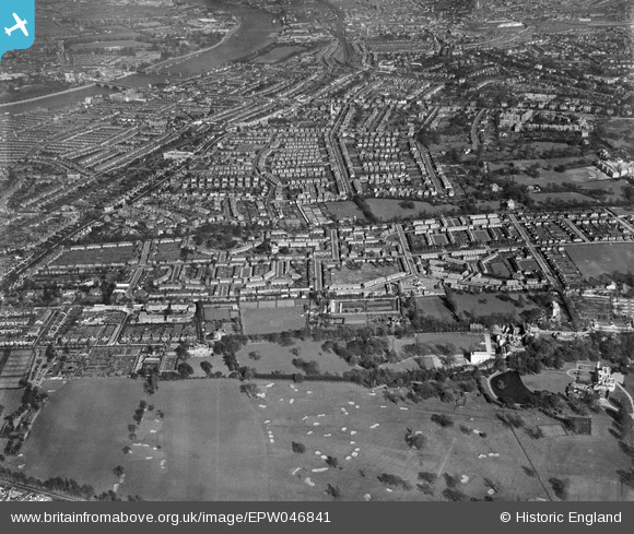
EPW046841 ENGLAND (1935). The Roehampton Club Golf Course and the surrounding residential area, Roehampton, 1935
    © Copyright OpenStreetMap contributors and licensed by the OpenStreetMap Foundation. 2025. Cartography is licensed as CC BY-SA.
  
Nearby Images (11)
Details
| Title | [EPW046841] The Roehampton Club Golf Course and the surrounding residential area, Roehampton, 1935 | 
| Reference | EPW046841 | 
| Date | May-1935 | 
| Link | |
| Place name | ROEHAMPTON | 
| Parish | |
| District | |
| Country | ENGLAND | 
| Easting / Northing | 522561, 174865 | 
| Longitude / Latitude | -0.23566695424466, 51.458987824261 | 
| National Grid Reference | TQ226749 | 
 
             
  ![[EPW046841] The Roehampton Club Golf Course and the surrounding residential area, Roehampton, 1935](http://britainfromabove.org.uk/sites/all/libraries/aerofilms-images/public/100x100/EPW/046/EPW046841.jpg) 
  
                                          ![[EPW046845] The residential area surrounding Dover House Road and Putney Park Lane, Roehampton, 1935](http://britainfromabove.org.uk/sites/all/libraries/aerofilms-images/public/100x100/EPW/046/EPW046845.jpg) 
 ![[EPW046846] The residential area surrounding Putney Park Lane, Roehampton, 1935](http://britainfromabove.org.uk/sites/all/libraries/aerofilms-images/public/100x100/EPW/046/EPW046846.jpg) 
 ![[EPW046842] The Roehampton Club Polo Ground and the surrounding residential area, Roehampton, 1935](http://britainfromabove.org.uk/sites/all/libraries/aerofilms-images/public/100x100/EPW/046/EPW046842.jpg) 
 ![[EPW046843] The residential area surrounding Swinburne Road and Howard's Lane, Roehampton, 1935](http://britainfromabove.org.uk/sites/all/libraries/aerofilms-images/public/100x100/EPW/046/EPW046843.jpg) 
 ![[EPW046849] The residential area surrounding Huntingfield Road, Dover House Road and Putney Park Lane, Roehampton, 1935](http://britainfromabove.org.uk/sites/all/libraries/aerofilms-images/public/100x100/EPW/046/EPW046849.jpg) 
 ![[EPW046847] The residential area surrounding Huntingfield Road and The Pleasance, Roehampton, 1935. This image has been affected by flare.](http://britainfromabove.org.uk/sites/all/libraries/aerofilms-images/public/100x100/EPW/046/EPW046847.jpg) 
 ![[EPW046844] The Roehampton Club Golf Course and surrounding residential area, Roehampton, 1935](http://britainfromabove.org.uk/sites/all/libraries/aerofilms-images/public/100x100/EPW/046/EPW046844.jpg) 
 ![[EPW046848] The residential area surrounding Huntingfield Road and The Pleasance, Roehampton, 1935](http://britainfromabove.org.uk/sites/all/libraries/aerofilms-images/public/100x100/EPW/046/EPW046848.jpg) 
 ![[EPW046840] Grove House and the surrounding residential area, Roehampton, 1935](http://britainfromabove.org.uk/sites/all/libraries/aerofilms-images/public/100x100/EPW/046/EPW046840.jpg) 
 ![[EPW046839] The residential area surrounding Putney Park Lane, Roehampton, 1935](http://britainfromabove.org.uk/sites/all/libraries/aerofilms-images/public/100x100/EPW/046/EPW046839.jpg) 
  Froebel College
 Froebel College