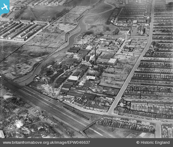
EPW046637 ENGLAND (1935). Howards and Sons Ltd Uphall Chemical Works and environs, Loxford, 1935
© Copyright OpenStreetMap contributors and licensed by the OpenStreetMap Foundation. 2026. Cartography is licensed as CC BY-SA.
Nearby Images (19)
Details
| Title | [EPW046637] Howards and Sons Ltd Uphall Chemical Works and environs, Loxford, 1935 |
| Reference | EPW046637 |
| Date | March-1935 |
| Link | |
| Place name | LOXFORD |
| Parish | |
| District | |
| Country | ENGLAND |
| Easting / Northing | 543726, 184943 |
| Longitude / Latitude | 0.072923309606841, 51.544576467192 |
| National Grid Reference | TQ437849 |
Pins
Be the first to add a comment to this image!


![[EPW046637] Howards and Sons Ltd Uphall Chemical Works and environs, Loxford, 1935](http://britainfromabove.org.uk/sites/all/libraries/aerofilms-images/public/100x100/EPW/046/EPW046637.jpg)
![[EPW046638] Howards and Sons Ltd Uphall Chemical Works and environs, Loxford, 1935](http://britainfromabove.org.uk/sites/all/libraries/aerofilms-images/public/100x100/EPW/046/EPW046638.jpg)
![[EPW046632] Howards and Sons Ltd Uphall Chemical Works, Loxford, 1935](http://britainfromabove.org.uk/sites/all/libraries/aerofilms-images/public/100x100/EPW/046/EPW046632.jpg)
![[EPW046631] Howards and Sons Ltd Uphall Chemical Works, Loxford, 1935](http://britainfromabove.org.uk/sites/all/libraries/aerofilms-images/public/100x100/EPW/046/EPW046631.jpg)
![[EPW046635] Howards and Sons Ltd Uphall Chemical Works, Loxford, 1935](http://britainfromabove.org.uk/sites/all/libraries/aerofilms-images/public/100x100/EPW/046/EPW046635.jpg)
![[EAW005298] The River Roding, Howards and Sons Uphall Chemical Works and adjacent residential streets, Loxford, 1947](http://britainfromabove.org.uk/sites/all/libraries/aerofilms-images/public/100x100/EAW/005/EAW005298.jpg)
![[EPW046636] Howards and Sons Ltd Uphall Chemical Works, Loxford, 1935](http://britainfromabove.org.uk/sites/all/libraries/aerofilms-images/public/100x100/EPW/046/EPW046636.jpg)
![[EAW005297] The River Roding, Howards and Sons Uphall Chemical Works and adjacent residential streets, Loxford, 1947](http://britainfromabove.org.uk/sites/all/libraries/aerofilms-images/public/100x100/EAW/005/EAW005297.jpg)
![[EPW046634] Howards and Sons Ltd Uphall Chemical Works, Loxford, 1935](http://britainfromabove.org.uk/sites/all/libraries/aerofilms-images/public/100x100/EPW/046/EPW046634.jpg)
![[EAW005295] The River Roding, Howards and Sons Uphall Chemical Works and adjacent residential streets, Loxford, 1947](http://britainfromabove.org.uk/sites/all/libraries/aerofilms-images/public/100x100/EAW/005/EAW005295.jpg)
![[EAW005294] Howards and Sons Uphall Chemical Works and adjacent residential streets, Loxford, 1947](http://britainfromabove.org.uk/sites/all/libraries/aerofilms-images/public/100x100/EAW/005/EAW005294.jpg)
![[EAW005296] Howards and Sons Uphall Chemical Works, Loxford, 1947](http://britainfromabove.org.uk/sites/all/libraries/aerofilms-images/public/100x100/EAW/005/EAW005296.jpg)
![[EPW046633] Howards and Sons Ltd Uphall Chemical Works, Loxford, 1935](http://britainfromabove.org.uk/sites/all/libraries/aerofilms-images/public/100x100/EPW/046/EPW046633.jpg)
![[EPW046639] Howards and Sons Ltd Uphall Chemical Works and environs, Loxford, 1935](http://britainfromabove.org.uk/sites/all/libraries/aerofilms-images/public/100x100/EPW/046/EPW046639.jpg)
![[EAW005292] The River Roding, Howards and Sons Uphall Chemical Works and adjacent residential streets, Loxford, 1947](http://britainfromabove.org.uk/sites/all/libraries/aerofilms-images/public/100x100/EAW/005/EAW005292.jpg)
![[EAW005293] The River Roding, Howards and Sons Uphall Chemical Works and adjacent residential streets, Loxford, 1947](http://britainfromabove.org.uk/sites/all/libraries/aerofilms-images/public/100x100/EAW/005/EAW005293.jpg)
![[EAW005291] The River Roding, Howards and Sons Uphall Chemical Works and adjacent residential streets, Loxford, 1947](http://britainfromabove.org.uk/sites/all/libraries/aerofilms-images/public/100x100/EAW/005/EAW005291.jpg)
![[EAW037661] The Thames Plywood Manufactory Ltd Works, Barking, 1951. This image has been produced from a print marked by Aerofilms Ltd for photo editing.](http://britainfromabove.org.uk/sites/all/libraries/aerofilms-images/public/100x100/EAW/037/EAW037661.jpg)
![[EAW037663] The Thames Plywood Manufactory Ltd Works, Barking, 1951. This image has been produced from a print marked by Aerofilms Ltd for photo editing.](http://britainfromabove.org.uk/sites/all/libraries/aerofilms-images/public/100x100/EAW/037/EAW037663.jpg)