
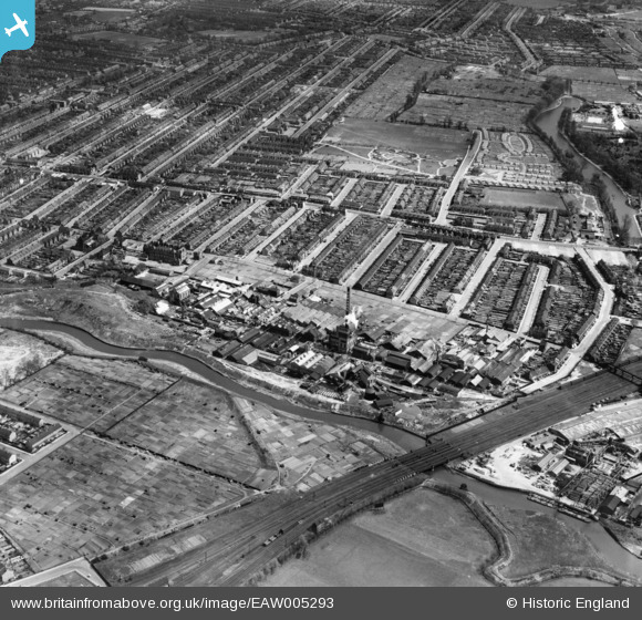
EAW005293 ENGLAND (1947). The River Roding, Howards and Sons Uphall Chemical Works and adjacent residential streets, Loxford, 1947
© Copyright OpenStreetMap contributors and licensed by the OpenStreetMap Foundation. 2026. Cartography is licensed as CC BY-SA.
Nearby Images (17)
EAW005293

EAW005292

EPW046633

EAW005296

EAW005291

EAW005294

EAW005295

EPW046636

EAW005297

EPW046638

EPW046632

EPW046639

EPW046635

EPW046637

EPW046631

EAW005298

EPW046634

Details
| Title | [EAW005293] The River Roding, Howards and Sons Uphall Chemical Works and adjacent residential streets, Loxford, 1947 |
| Reference | EAW005293 |
| Date | 29-April-1947 |
| Link | |
| Place name | LOXFORD |
| Parish | |
| District | |
| Country | ENGLAND |
| Easting / Northing | 543814, 185055 |
| Longitude / Latitude | 0.074237399115198, 51.54556053779 |
| National Grid Reference | TQ438851 |
Pins

Matt Aldred edob.mattaldred.com |
Thursday 11th of March 2021 10:10:56 PM | |
|
Matt Aldred edob.mattaldred.com |
Thursday 11th of March 2021 10:10:24 PM | |

pl8man |
Sunday 21st of February 2021 02:16:45 PM | |

Sparky |
Thursday 5th of October 2017 06:01:21 PM | |
|
Sparky |
Thursday 5th of October 2017 06:01:03 PM | |
|
Hermann the German |
Saturday 8th of July 2017 08:57:06 PM | |
|
Hermann the German |
Saturday 8th of July 2017 08:52:07 PM | |
|
Hermann the German |
Saturday 8th of July 2017 08:47:04 PM | |
|
Hermann the German |
Saturday 8th of July 2017 08:43:46 PM | |
|
Hermann the German |
Saturday 8th of July 2017 08:41:03 PM | |
|
Hermann the German |
Saturday 8th of July 2017 08:35:39 PM | |
|
Hermann the German |
Saturday 8th of July 2017 08:33:42 PM | |
|
Hermann the German |
Saturday 8th of July 2017 08:30:24 PM | |
|
Hermann the German |
Saturday 8th of July 2017 08:26:13 PM | |
|
Hermann the German |
Saturday 8th of July 2017 08:24:26 PM | |
|
Hermann the German |
Saturday 8th of July 2017 08:14:44 PM | |
|
Hermann the German |
Saturday 8th of July 2017 08:11:00 PM | |
|
Hermann the German |
Saturday 8th of July 2017 08:04:05 PM | |
|
Hermann the German |
Saturday 8th of July 2017 07:48:43 PM | |
|
Hermann the German |
Saturday 8th of July 2017 07:46:31 PM | |
|
Hermann the German |
Saturday 8th of July 2017 07:44:30 PM | |
|
Hermann the German |
Saturday 8th of July 2017 07:42:46 PM | |
|
pl8man |
Thursday 1st of December 2016 01:50:37 PM |