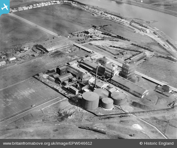
EPW046612 ENGLAND (1935). The Solvent Products Works, Dagenham, 1935
© Copyright OpenStreetMap contributors and licensed by the OpenStreetMap Foundation. 2026. Cartography is licensed as CC BY-SA.
Nearby Images (29)
Details
| Title | [EPW046612] The Solvent Products Works, Dagenham, 1935 |
| Reference | EPW046612 |
| Date | March-1935 |
| Link | |
| Place name | DAGENHAM |
| Parish | |
| District | |
| Country | ENGLAND |
| Easting / Northing | 548865, 182201 |
| Longitude / Latitude | 0.14582749683387, 51.518604111927 |
| National Grid Reference | TQ489822 |
Pins
Be the first to add a comment to this image!


![[EPW046612] The Solvent Products Works, Dagenham, 1935](http://britainfromabove.org.uk/sites/all/libraries/aerofilms-images/public/100x100/EPW/046/EPW046612.jpg)
![[EPW046613] The Solvent Products Works and environs, Dagenham, 1935](http://britainfromabove.org.uk/sites/all/libraries/aerofilms-images/public/100x100/EPW/046/EPW046613.jpg)
![[EPW046615] The Solvent Products Works, Dagenham, 1935](http://britainfromabove.org.uk/sites/all/libraries/aerofilms-images/public/100x100/EPW/046/EPW046615.jpg)
![[EPW021393] The Solvent Products Works, Dagenham, 1928](http://britainfromabove.org.uk/sites/all/libraries/aerofilms-images/public/100x100/EPW/021/EPW021393.jpg)
![[EPW046549] The Solvent Products Ltd Works, Dagenham, 1935](http://britainfromabove.org.uk/sites/all/libraries/aerofilms-images/public/100x100/EPW/046/EPW046549.jpg)
![[EPW009946] Factories and piers at Chequers Lane, Dagenham, 1924](http://britainfromabove.org.uk/sites/all/libraries/aerofilms-images/public/100x100/EPW/009/EPW009946.jpg)
![[EPW021396] The Solvent Products Works, Dagenham, 1928](http://britainfromabove.org.uk/sites/all/libraries/aerofilms-images/public/100x100/EPW/021/EPW021396.jpg)
![[EPW046550] The Solvent Products Ltd Works, Dagenham, 1935](http://britainfromabove.org.uk/sites/all/libraries/aerofilms-images/public/100x100/EPW/046/EPW046550.jpg)
![[EPW021394] The Solvent Products Works, Dagenham, 1928](http://britainfromabove.org.uk/sites/all/libraries/aerofilms-images/public/100x100/EPW/021/EPW021394.jpg)
![[EPW046553] The Solvent Products Ltd Works, Dagenham, 1935](http://britainfromabove.org.uk/sites/all/libraries/aerofilms-images/public/100x100/EPW/046/EPW046553.jpg)
![[EPW046547] The Solvent Products Ltd Works, Dagenham, 1935](http://britainfromabove.org.uk/sites/all/libraries/aerofilms-images/public/100x100/EPW/046/EPW046547.jpg)
![[EPW046548] The Solvent Products Ltd Works, Dagenham, 1935](http://britainfromabove.org.uk/sites/all/libraries/aerofilms-images/public/100x100/EPW/046/EPW046548.jpg)
![[EPW046552] The Solvent Products Ltd Works, Dagenham, 1935](http://britainfromabove.org.uk/sites/all/libraries/aerofilms-images/public/100x100/EPW/046/EPW046552.jpg)
![[EPW046515] The Solvent Products Ltd Works, Dagenham, 1935](http://britainfromabove.org.uk/sites/all/libraries/aerofilms-images/public/100x100/EPW/046/EPW046515.jpg)
![[EPW021391] The Solvent Products Works, Dagenham, 1928](http://britainfromabove.org.uk/sites/all/libraries/aerofilms-images/public/100x100/EPW/021/EPW021391.jpg)
![[EAW046775] The jetties, depots and industrial premises at Horse Shoe Corner, Dagenham, from the south-east, 1952. This image was marked by Aerofilms Ltd for photo editing.](http://britainfromabove.org.uk/sites/all/libraries/aerofilms-images/public/100x100/EAW/046/EAW046775.jpg)
![[EPW009951] Dagenham Dock and factories on Chequers Lane, Dagenham, 1924](http://britainfromabove.org.uk/sites/all/libraries/aerofilms-images/public/100x100/EPW/009/EPW009951.jpg)
![[EPW021395] The Solvent Products Works, Dagenham, 1928](http://britainfromabove.org.uk/sites/all/libraries/aerofilms-images/public/100x100/EPW/021/EPW021395.jpg)
![[EAW031165] The fuel storage depot beside Dagenham Dock, Dagenham, 1950. This image was marked by Aerofilms Ltd for photo editing.](http://britainfromabove.org.uk/sites/all/libraries/aerofilms-images/public/100x100/EAW/031/EAW031165.jpg)
![[EPW046546] Dagenham Dock, Dagenham Marshes and the Solvent Products Ltd Works, Dagenham, 1935](http://britainfromabove.org.uk/sites/all/libraries/aerofilms-images/public/100x100/EPW/046/EPW046546.jpg)
![[EAW046778] The jetties, depots and industrial premises at Horse Shoe Corner, Dagenham, from the south, 1952. This image was marked by Aerofilms Ltd for photo editing.](http://britainfromabove.org.uk/sites/all/libraries/aerofilms-images/public/100x100/EAW/046/EAW046778.jpg)
![[EAW031166] The fuel storage depot beside Dagenham Dock, Dagenham, 1950](http://britainfromabove.org.uk/sites/all/libraries/aerofilms-images/public/100x100/EAW/031/EAW031166.jpg)
![[EAW046771] The jetties, depots and industrial premises at Horse Shoe Corner, Dagenham, from the south-east, 1952. This image was marked by Aerofilms Ltd for photo editing.](http://britainfromabove.org.uk/sites/all/libraries/aerofilms-images/public/100x100/EAW/046/EAW046771.jpg)
![[EAW031159] The fuel storage depot beside Dagenham Dock, Dagenham, 1950. This image was marked by Aerofilms Ltd for photo editing.](http://britainfromabove.org.uk/sites/all/libraries/aerofilms-images/public/100x100/EAW/031/EAW031159.jpg)
![[EAW031163] The fuel storage depot beside Dagenham Dock, Dagenham, 1950. This image was marked by Aerofilms Ltd for photo editing.](http://britainfromabove.org.uk/sites/all/libraries/aerofilms-images/public/100x100/EAW/031/EAW031163.jpg)
![[EAW046780] The jetties, depots and industrial premises at Horse Shoe Corner, Dagenham, 1952. This image was marked by Aerofilms Ltd for photo editing.](http://britainfromabove.org.uk/sites/all/libraries/aerofilms-images/public/100x100/EAW/046/EAW046780.jpg)
![[EPW046614] The Solvent Products Works and environs, Dagenham, 1935](http://britainfromabove.org.uk/sites/all/libraries/aerofilms-images/public/100x100/EPW/046/EPW046614.jpg)
![[EPW009947] Dagenham Dock and the River Thames, Dagenham, from the north-west, 1924](http://britainfromabove.org.uk/sites/all/libraries/aerofilms-images/public/100x100/EPW/009/EPW009947.jpg)
![[EPW046551] Dagenham Docks, the Dagenham Marshes and the Solvent Products Ltd Works, Dagenham, 1935](http://britainfromabove.org.uk/sites/all/libraries/aerofilms-images/public/100x100/EPW/046/EPW046551.jpg)