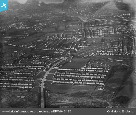
EPW046495 ENGLAND (1935). Residential development around Rayners Lane Station, Rayners Lane, 1935
    © Copyright OpenStreetMap contributors and licensed by the OpenStreetMap Foundation. 2025. Cartography is licensed as CC BY-SA.
  
Nearby Images (7)
Details
| Title | [EPW046495] Residential development around Rayners Lane Station, Rayners Lane, 1935 | 
| Reference | EPW046495 | 
| Date | January-1935 | 
| Link | |
| Place name | RAYNERS LANE | 
| Parish | |
| District | |
| Country | ENGLAND | 
| Easting / Northing | 512966, 187549 | 
| Longitude / Latitude | -0.36966324643929, 51.574998938613 | 
| National Grid Reference | TQ130875 | 
Pins
Be the first to add a comment to this image!
 
             
  ![[EPW046495] Residential development around Rayners Lane Station, Rayners Lane, 1935](http://britainfromabove.org.uk/sites/all/libraries/aerofilms-images/public/100x100/EPW/046/EPW046495.jpg) 
  
                                          ![[EPW046491] Residential development around Rayners Lane Station, Rayners Lane, 1935](http://britainfromabove.org.uk/sites/all/libraries/aerofilms-images/public/100x100/EPW/046/EPW046491.jpg) 
 ![[EPW044508] The London Passenger Transport Board Metropolitan Line at Rayners Lane Junction,  Alexandra Avenue and environs, Rayners Lane, 1934](http://britainfromabove.org.uk/sites/all/libraries/aerofilms-images/public/100x100/EPW/044/EPW044508.jpg) 
 ![[EPW046494] Residential development around Rayners Lane Station, Rayners Lane, 1935](http://britainfromabove.org.uk/sites/all/libraries/aerofilms-images/public/100x100/EPW/046/EPW046494.jpg) 
 ![[EPW031581] High Worple, Rayners Lane Railway Station and houses under construction at Rayners Lane, Rayners Lane, 1930](http://britainfromabove.org.uk/sites/all/libraries/aerofilms-images/public/100x100/EPW/031/EPW031581.jpg) 
 ![[EPW044208] Alexandra Avenue, Rayners Lane Station and environs, Rayners Lane, 1934](http://britainfromabove.org.uk/sites/all/libraries/aerofilms-images/public/100x100/EPW/044/EPW044208.jpg) 
 ![[EPW044204] The LPTB Metropolitan Line and environs to the west of Rayners Lane Station, Rayners Lane, 1934](http://britainfromabove.org.uk/sites/all/libraries/aerofilms-images/public/100x100/EPW/044/EPW044204.jpg)