
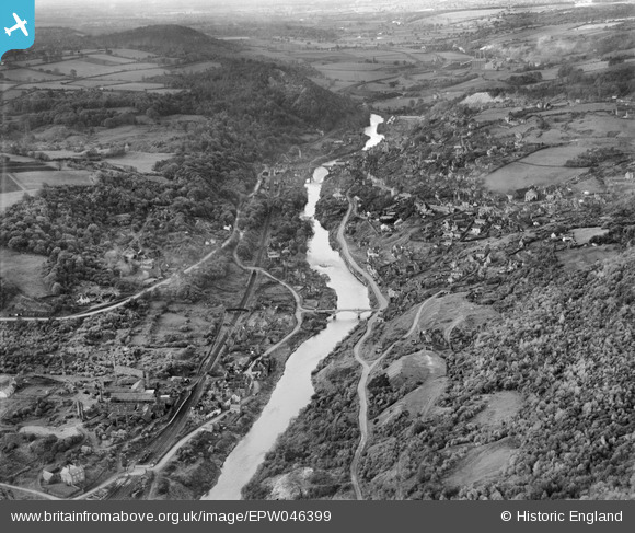
EPW046399 ENGLAND (1934). Ironbridge Gorge, Ironbridge, from the east, 1934
© Copyright OpenStreetMap contributors and licensed by the OpenStreetMap Foundation. 2026. Cartography is licensed as CC BY-SA.
Nearby Images (7)
EPW046399

EPW046403

EPW046405

EPW046400

EAW012588

EAW012673

EPW046397

Details
| Title | [EPW046399] Ironbridge Gorge, Ironbridge, from the east, 1934 |
| Reference | EPW046399 |
| Date | October-1934 |
| Link | |
| Place name | IRONBRIDGE |
| Parish | THE GORGE |
| District | |
| Country | ENGLAND |
| Easting / Northing | 368319, 303233 |
| Longitude / Latitude | -2.4680806755129, 52.625579943544 |
| National Grid Reference | SJ683032 |
Pins

Empee |
Thursday 4th of February 2016 10:49:58 AM | |
|
Empee |
Thursday 4th of February 2016 10:47:28 AM | |
|
severnsider |
Wednesday 18th of November 2015 02:38:06 PM | |
|
severnsider |
Wednesday 18th of November 2015 02:37:31 PM |
User Comment Contributions
Ironbridge |

Alan McFaden |
Friday 31st of October 2014 09:20:06 AM |
The Iron Bridge |
Alan McFaden |
Friday 31st of October 2014 09:19:42 AM |