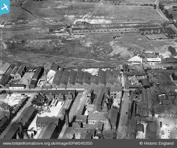
EPW045350 ENGLAND (1934). The British Earthenware Pottery, Tunstall, 1934
© Copyright OpenStreetMap contributors and licensed by the OpenStreetMap Foundation. 2026. Cartography is licensed as CC BY-SA.
Nearby Images (8)
Details
| Title | [EPW045350] The British Earthenware Pottery, Tunstall, 1934 |
| Reference | EPW045350 |
| Date | July-1934 |
| Link | |
| Place name | TUNSTALL |
| Parish | |
| District | |
| Country | ENGLAND |
| Easting / Northing | 385918, 351841 |
| Longitude / Latitude | -2.2101614086267, 53.063326906362 |
| National Grid Reference | SJ859518 |
Pins

Acme |
Sunday 26th of July 2015 01:02:57 AM | |

Acme |
Sunday 26th of July 2015 01:02:52 AM | |

bescotbeast |
Sunday 15th of September 2013 03:21:53 PM | |

bescotbeast |
Sunday 15th of September 2013 03:20:28 PM | |
Furlong Road?? |

AP |
Friday 24th of February 2017 01:00:45 PM |

bescotbeast |
Sunday 15th of September 2013 03:19:48 PM | |

bescotbeast |
Sunday 15th of September 2013 03:17:55 PM |


![[EPW045350] The British Earthenware Pottery, Tunstall, 1934](http://britainfromabove.org.uk/sites/all/libraries/aerofilms-images/public/100x100/EPW/045/EPW045350.jpg)
![[EPW045347] The British Earthenware Pottery, Tunstall, 1934](http://britainfromabove.org.uk/sites/all/libraries/aerofilms-images/public/100x100/EPW/045/EPW045347.jpg)
![[EPW045348] The British Earthenware Pottery, Christ Church and environs, Tunstall, 1934](http://britainfromabove.org.uk/sites/all/libraries/aerofilms-images/public/100x100/EPW/045/EPW045348.jpg)
![[EPW045349] The British Earthenware Pottery and Christ Church, Tunstall, 1934](http://britainfromabove.org.uk/sites/all/libraries/aerofilms-images/public/100x100/EPW/045/EPW045349.jpg)
![[EPW045351] The British Earthenware Pottery, Christ Church and environs, Tunstall, 1934](http://britainfromabove.org.uk/sites/all/libraries/aerofilms-images/public/100x100/EPW/045/EPW045351.jpg)
![[EPW045346] The British Earthenware Pottery, Christ Church and environs, Tunstall, 1934](http://britainfromabove.org.uk/sites/all/libraries/aerofilms-images/public/100x100/EPW/045/EPW045346.jpg)
![[EPW054088] The British Pottery and Royal Albert and Victoria Potteries, Tunstall, 1937](http://britainfromabove.org.uk/sites/all/libraries/aerofilms-images/public/100x100/EPW/054/EPW054088.jpg)
![[EPW054089] Christ Church and potteries off the High Street, Tunstall, 1937](http://britainfromabove.org.uk/sites/all/libraries/aerofilms-images/public/100x100/EPW/054/EPW054089.jpg)