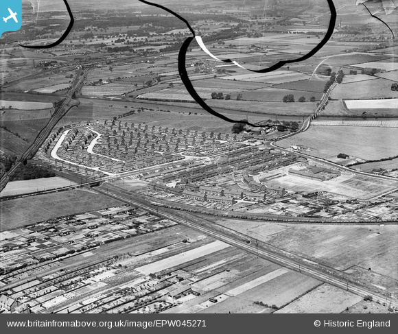
EPW045271 ENGLAND (1934). Housing estate at Whitwood Mere, Castleford, 1934. This image has been produced from a damaged negative.
© Copyright OpenStreetMap contributors and licensed by the OpenStreetMap Foundation. 2026. Cartography is licensed as CC BY-SA.
Details
| Title | [EPW045271] Housing estate at Whitwood Mere, Castleford, 1934. This image has been produced from a damaged negative. |
| Reference | EPW045271 |
| Date | July-1934 |
| Link | |
| Place name | CASTLEFORD |
| Parish | |
| District | |
| Country | ENGLAND |
| Easting / Northing | 441105, 425458 |
| Longitude / Latitude | -1.3769714953785, 53.723681853756 |
| National Grid Reference | SE411255 |
Pins

Phil |
Wednesday 13th of January 2021 12:18:37 PM | |

Phil |
Wednesday 13th of January 2021 12:17:16 PM | |

Steve Glover |
Saturday 20th of January 2018 06:06:07 PM | |

Steve Glover |
Saturday 20th of January 2018 06:04:33 PM | |

Derekdye |
Sunday 17th of November 2013 09:28:35 PM | |

Derekdye |
Sunday 17th of November 2013 09:26:34 PM | |

Derekdye |
Sunday 17th of November 2013 09:24:52 PM |


![[EPW045271] Housing estate at Whitwood Mere, Castleford, 1934. This image has been produced from a damaged negative.](http://britainfromabove.org.uk/sites/all/libraries/aerofilms-images/public/100x100/EPW/045/EPW045271.jpg)
![[EPW045273] Housing estate at Whitwood Mere, Castleford, 1934. This image has been produced from a damaged negative.](http://britainfromabove.org.uk/sites/all/libraries/aerofilms-images/public/100x100/EPW/045/EPW045273.jpg)
![[EPW045276] Housing estate at Whitwood Mere and Lumley Hill, Castleford, 1934. This image has been produced from a damaged negative.](http://britainfromabove.org.uk/sites/all/libraries/aerofilms-images/public/100x100/EPW/045/EPW045276.jpg)
![[EPW045274] Housing estate at Whitwood Mere, Castleford, from the south-west, 1934. This image has been produced from a damaged negative.](http://britainfromabove.org.uk/sites/all/libraries/aerofilms-images/public/100x100/EPW/045/EPW045274.jpg)